You are here: Home > Network List > TA - USArray Transportable Network (new EarthScope stations) Stations List
> Station H23K Yukon River, AK, USA > Earthquake Result Viewer
H23K Yukon River, AK, USA - Earthquake Result Viewer
| Earthquake location: |
Southern Xinjiang, China |
| Earthquake latitude/longitude: |
37.5/78.1 |
| Earthquake time(UTC): |
2015/07/03 (184) 01:07:45 GMT |
| Earthquake Depth: |
10 km |
| Earthquake Magnitude: |
6.1 MB |
| Earthquake Catalog/Contributor: |
NEIC PDE/NEIC ALERT |
|
| Network: |
TA USArray Transportable Network (new EarthScope stations) |
| Station: |
H23K Yukon River, AK, USA |
| Lat/Lon: |
65.83 N/149.54 W |
| Elevation: |
617 m |
|
| Distance: |
70.6 deg |
| Az: |
18.827 deg |
| Baz: |
321.428 deg |
| Ray Param: |
0.054844387 |
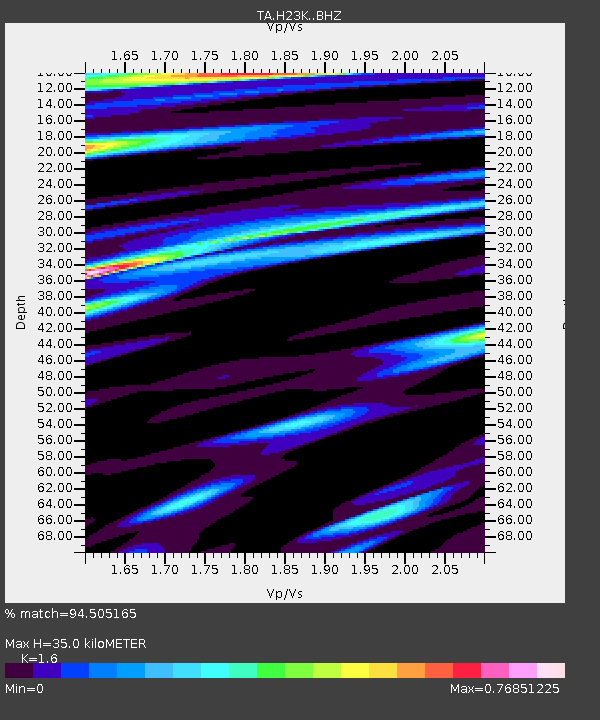
| Estimated Moho Depth: |
35.0 km |
| Estimated Crust Vp/Vs: |
1.60 |
| Assumed Crust Vp: |
6.566 km/s |
| Estimated Crust Vs: |
4.104 km/s |
| Estimated Crust Poisson's Ratio: |
0.18 |
|
| Radial Match: |
94.505165 % |
| Radial Bump: |
400 |
| Transverse Match: |
81.3531 % |
| Transverse Bump: |
400 |
| SOD ConfigId: |
7422571 |
| Insert Time: |
2019-04-19 14:32:40.496 +0000 |
| GWidth: |
2.5 |
| Max Bumps: |
400 |
| Tol: |
0.001 |
|

Signal To Noise
| Channel | StoN | STA | LTA |
| TA:H23K: :BHZ:20150703T01:18:29.249988Z | 2.5560575 | 2.4194176E-7 | 9.4654276E-8 |
| TA:H23K: :BHN:20150703T01:18:29.249988Z | 1.2868792 | 7.6291535E-8 | 5.9284144E-8 |
| TA:H23K: :BHE:20150703T01:18:29.249988Z | 1.5496131 | 8.420221E-8 | 5.433757E-8 |
| Arrivals |
| Ps | 3.3 SECOND |
| PpPs | 13 SECOND |
| PsPs/PpSs | 17 SECOND |


