You are here: Home > Network List > TA - USArray Transportable Network (new EarthScope stations) Stations List
> Station M20K Styx River, AK, USA > Earthquake Result Viewer
M20K Styx River, AK, USA - Earthquake Result Viewer
| Earthquake location: |
Southern Xinjiang, China |
| Earthquake latitude/longitude: |
37.5/78.1 |
| Earthquake time(UTC): |
2015/07/03 (184) 01:07:45 GMT |
| Earthquake Depth: |
10 km |
| Earthquake Magnitude: |
6.1 MB |
| Earthquake Catalog/Contributor: |
NEIC PDE/NEIC ALERT |
|
| Network: |
TA USArray Transportable Network (new EarthScope stations) |
| Station: |
M20K Styx River, AK, USA |
| Lat/Lon: |
61.88 N/153.13 W |
| Elevation: |
1107 m |
|
| Distance: |
72.7 deg |
| Az: |
22.774 deg |
| Baz: |
319.45 deg |
| Ray Param: |
0.053497512 |
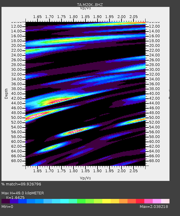
| Estimated Moho Depth: |
49.0 km |
| Estimated Crust Vp/Vs: |
1.64 |
| Assumed Crust Vp: |
6.566 km/s |
| Estimated Crust Vs: |
3.998 km/s |
| Estimated Crust Poisson's Ratio: |
0.21 |
|
| Radial Match: |
89.926796 % |
| Radial Bump: |
400 |
| Transverse Match: |
73.393776 % |
| Transverse Bump: |
400 |
| SOD ConfigId: |
7422571 |
| Insert Time: |
2019-04-19 14:32:55.939 +0000 |
| GWidth: |
2.5 |
| Max Bumps: |
400 |
| Tol: |
0.001 |
|

Signal To Noise
| Channel | StoN | STA | LTA |
| TA:M20K: :BHZ:20150703T01:18:41.499988Z | 3.5571945 | 2.6127358E-7 | 7.3449336E-8 |
| TA:M20K: :BHN:20150703T01:18:41.499988Z | 0.9570672 | 1.2330213E-7 | 1.2883329E-7 |
| TA:M20K: :BHE:20150703T01:18:41.499988Z | 1.4113771 | 2.0538096E-7 | 1.4551813E-7 |
| Arrivals |
| Ps | 5.0 SECOND |
| PpPs | 19 SECOND |
| PsPs/PpSs | 24 SECOND |


