You are here: Home > Network List > TA - USArray Transportable Network (new EarthScope stations) Stations List
> Station O18K Koktuh Hills, AK, USA > Earthquake Result Viewer
O18K Koktuh Hills, AK, USA - Earthquake Result Viewer

| Earthquake location: |
Southern Xinjiang, China |
| Earthquake latitude/longitude: |
37.5/78.1 |
| Earthquake time(UTC): |
2015/07/03 (184) 01:07:45 GMT |
| Earthquake Depth: |
10 km |
| Earthquake Magnitude: |
6.1 MB |
| Earthquake Catalog/Contributor: |
NEIC PDE/NEIC ALERT |
|
| Network: |
TA USArray Transportable Network (new EarthScope stations) |
| Station: |
O18K Koktuh Hills, AK, USA |
| Lat/Lon: |
59.85 N/155.21 W |
| Elevation: |
544 m |
|
| Distance: |
73.6 deg |
| Az: |
24.972 deg |
| Baz: |
318.278 deg |
| Ray Param: |
0.05292921 |
| Estimated Moho Depth: |
33.25 km |
| Estimated Crust Vp/Vs: |
1.91 |
| Assumed Crust Vp: |
6.438 km/s |
| Estimated Crust Vs: |
3.366 km/s |
| Estimated Crust Poisson's Ratio: |
0.31 |
|
| Radial Match: |
94.472176 % |
| Radial Bump: |
373 |
| Transverse Match: |
85.889435 % |
| Transverse Bump: |
400 |
| SOD ConfigId: |
7422571 |
| Insert Time: |
2019-04-19 14:32:59.192 +0000 |
| GWidth: |
2.5 |
| Max Bumps: |
400 |
| Tol: |
0.001 |
|
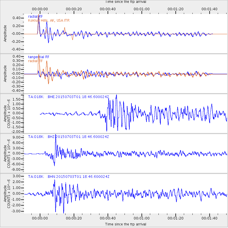
Signal To Noise
| Channel | StoN | STA | LTA |
| TA:O18K: :BHZ:20150703T01:18:46.600024Z | 4.1473556 | 4.7109705E-7 | 1.1358975E-7 |
| TA:O18K: :BHN:20150703T01:18:46.600024Z | 2.3042667 | 1.7793008E-7 | 7.721766E-8 |
| TA:O18K: :BHE:20150703T01:18:46.600024Z | 1.7162724 | 1.4284743E-7 | 8.3231214E-8 |
| Arrivals |
| Ps | 4.9 SECOND |
| PpPs | 15 SECOND |
| PsPs/PpSs | 19 SECOND |


