You are here: Home > Network List > YQ13 - Study of Extension and Magmatism in Malawi and Tanzania Stations List
> Station KURU Muhukuru,Tanzania > Earthquake Result Viewer
KURU Muhukuru,Tanzania - Earthquake Result Viewer
| Earthquake location: |
Southern Xinjiang, China |
| Earthquake latitude/longitude: |
37.5/78.1 |
| Earthquake time(UTC): |
2015/07/03 (184) 01:07:45 GMT |
| Earthquake Depth: |
10 km |
| Earthquake Magnitude: |
6.1 MB |
| Earthquake Catalog/Contributor: |
NEIC PDE/NEIC ALERT |
|
| Network: |
YQ Study of Extension and Magmatism in Malawi and Tanzania |
| Station: |
KURU Muhukuru,Tanzania |
| Lat/Lon: |
11.20 S/35.46 E |
| Elevation: |
751 m |
|
| Distance: |
62.8 deg |
| Az: |
228.4 deg |
| Baz: |
37.328 deg |
| Ray Param: |
0.05998895 |
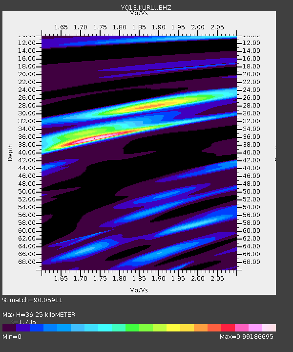
| Estimated Moho Depth: |
36.25 km |
| Estimated Crust Vp/Vs: |
1.74 |
| Assumed Crust Vp: |
6.502 km/s |
| Estimated Crust Vs: |
3.747 km/s |
| Estimated Crust Poisson's Ratio: |
0.25 |
|
| Radial Match: |
90.05911 % |
| Radial Bump: |
319 |
| Transverse Match: |
76.48041 % |
| Transverse Bump: |
400 |
| SOD ConfigId: |
7422571 |
| Insert Time: |
2019-04-19 14:34:20.377 +0000 |
| GWidth: |
2.5 |
| Max Bumps: |
400 |
| Tol: |
0.001 |
|

Signal To Noise
| Channel | StoN | STA | LTA |
| YQ:KURU: :BHZ:20150703T01:17:39.285022Z | 18.571674 | 1.4744094E-6 | 7.9390226E-8 |
| YQ:KURU: :BHN:20150703T01:17:39.285022Z | 7.917187 | 5.974396E-7 | 7.5461095E-8 |
| YQ:KURU: :BHE:20150703T01:17:39.285022Z | 7.8020916 | 5.1627745E-7 | 6.617168E-8 |
| Arrivals |
| Ps | 4.3 SECOND |
| PpPs | 15 SECOND |
| PsPs/PpSs | 19 SECOND |


