You are here: Home > Network List > YQ13 - Study of Extension and Magmatism in Malawi and Tanzania Stations List
> Station MLOW Mlowe,Malawi > Earthquake Result Viewer
MLOW Mlowe,Malawi - Earthquake Result Viewer
| Earthquake location: |
Southern Xinjiang, China |
| Earthquake latitude/longitude: |
37.5/78.1 |
| Earthquake time(UTC): |
2015/07/03 (184) 01:07:45 GMT |
| Earthquake Depth: |
10 km |
| Earthquake Magnitude: |
6.1 MB |
| Earthquake Catalog/Contributor: |
NEIC PDE/NEIC ALERT |
|
| Network: |
YQ Study of Extension and Magmatism in Malawi and Tanzania |
| Station: |
MLOW Mlowe,Malawi |
| Lat/Lon: |
10.78 S/34.21 E |
| Elevation: |
513 m |
|
| Distance: |
63.2 deg |
| Az: |
229.774 deg |
| Baz: |
38.189 deg |
| Ray Param: |
0.05971418 |
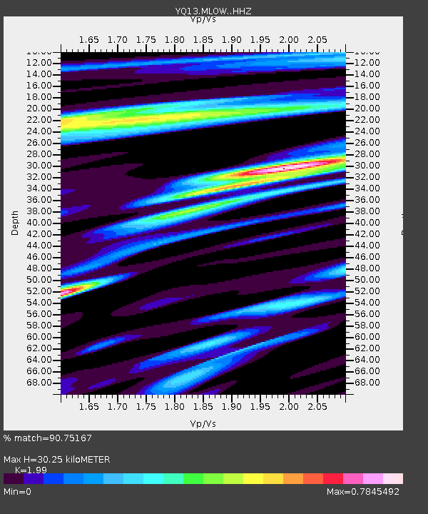
| Estimated Moho Depth: |
30.25 km |
| Estimated Crust Vp/Vs: |
1.99 |
| Assumed Crust Vp: |
6.502 km/s |
| Estimated Crust Vs: |
3.267 km/s |
| Estimated Crust Poisson's Ratio: |
0.33 |
|
| Radial Match: |
90.75167 % |
| Radial Bump: |
400 |
| Transverse Match: |
76.56497 % |
| Transverse Bump: |
400 |
| SOD ConfigId: |
7422571 |
| Insert Time: |
2019-04-19 14:34:29.223 +0000 |
| GWidth: |
2.5 |
| Max Bumps: |
400 |
| Tol: |
0.001 |
|

Signal To Noise
| Channel | StoN | STA | LTA |
| YQ:MLOW: :HHZ:20150703T01:17:42.090015Z | 9.269569 | 1.5387554E-6 | 1.6600075E-7 |
| YQ:MLOW: :HHN:20150703T01:17:42.090015Z | 2.6534204 | 5.200851E-7 | 1.9600554E-7 |
| YQ:MLOW: :HHE:20150703T01:17:42.090015Z | 4.4457088 | 7.428251E-7 | 1.670881E-7 |
| Arrivals |
| Ps | 4.8 SECOND |
| PpPs | 13 SECOND |
| PsPs/PpSs | 18 SECOND |


