You are here: Home > Network List > YQ13 - Study of Extension and Magmatism in Malawi and Tanzania Stations List
> Station THAN Thanula,Malawi > Earthquake Result Viewer
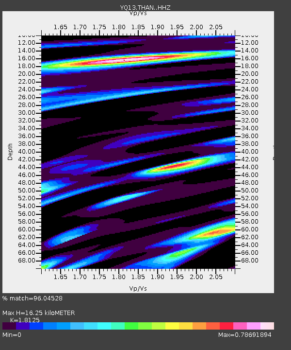
THAN Thanula,Malawi - Earthquake Result Viewer
| Earthquake location: |
Southern Xinjiang, China |
| Earthquake latitude/longitude: |
37.5/78.1 |
| Earthquake time(UTC): |
2015/07/03 (184) 01:07:45 GMT |
| Earthquake Depth: |
10 km |
| Earthquake Magnitude: |
6.1 MB |
| Earthquake Catalog/Contributor: |
NEIC PDE/NEIC ALERT |
|
| Network: |
YQ Study of Extension and Magmatism in Malawi and Tanzania |
| Station: |
THAN Thanula,Malawi |
| Lat/Lon: |
11.47 S/34.18 E |
| Elevation: |
683 m |
|
| Distance: |
63.8 deg |
| Az: |
229.324 deg |
| Baz: |
37.992 deg |
| Ray Param: |
0.05935669 |
| Estimated Moho Depth: |
16.25 km |
| Estimated Crust Vp/Vs: |
1.81 |
| Assumed Crust Vp: |
6.502 km/s |
| Estimated Crust Vs: |
3.587 km/s |
| Estimated Crust Poisson's Ratio: |
0.28 |
|
| Radial Match: |
96.04528 % |
| Radial Bump: |
343 |
| Transverse Match: |
86.31926 % |
| Transverse Bump: |
400 |
| SOD ConfigId: |
7422571 |
| Insert Time: |
2019-04-19 14:34:35.563 +0000 |
| GWidth: |
2.5 |
| Max Bumps: |
400 |
| Tol: |
0.001 |
|

Signal To Noise
| Channel | StoN | STA | LTA |
| YQ:THAN: :HHZ:20150703T01:17:45.72002Z | 20.649921 | 1.6692005E-6 | 8.083327E-8 |
| YQ:THAN: :HHN:20150703T01:17:45.72002Z | 11.674738 | 5.75118E-7 | 4.9261747E-8 |
| YQ:THAN: :HHE:20150703T01:17:45.72002Z | 9.342328 | 5.750582E-7 | 6.155406E-8 |
| Arrivals |
| Ps | 2.1 SECOND |
| PpPs | 6.7 SECOND |
| PsPs/PpSs | 8.9 SECOND |


