You are here: Home > Network List > IU - Global Seismograph Network (GSN - IRIS/USGS) Stations List
> Station KIEV Kiev, Ukraine > Earthquake Result Viewer
KIEV Kiev, Ukraine - Earthquake Result Viewer

| Earthquake location: |
Kuril Islands |
| Earthquake latitude/longitude: |
45.9/151.3 |
| Earthquake time(UTC): |
1995/04/17 (107) 23:28:08 GMT |
| Earthquake Depth: |
34 km |
| Earthquake Magnitude: |
6.1 MB, 6.3 MS, 6.2 UNKNOWN, 6.8 MW |
| Earthquake Catalog/Contributor: |
WHDF/NEIC |
|
| Network: |
IU Global Seismograph Network (GSN - IRIS/USGS) |
| Station: |
KIEV Kiev, Ukraine |
| Lat/Lon: |
50.69 N/29.21 E |
| Elevation: |
163 m |
|
| Distance: |
71.5 deg |
| Az: |
325.382 deg |
| Baz: |
38.589 deg |
| Ray Param: |
0.05420397 |
| Estimated Moho Depth: |
37.5 km |
| Estimated Crust Vp/Vs: |
1.79 |
| Assumed Crust Vp: |
6.552 km/s |
| Estimated Crust Vs: |
3.655 km/s |
| Estimated Crust Poisson's Ratio: |
0.27 |
|
| Radial Match: |
97.68579 % |
| Radial Bump: |
400 |
| Transverse Match: |
89.65447 % |
| Transverse Bump: |
400 |
| SOD ConfigId: |
6273 |
| Insert Time: |
2010-03-03 15:36:05.882 +0000 |
| GWidth: |
2.5 |
| Max Bumps: |
400 |
| Tol: |
0.001 |
|
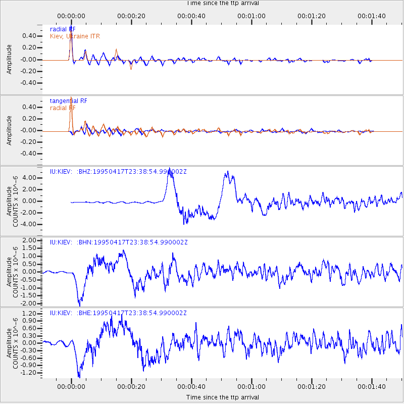
Signal To Noise
| Channel | StoN | STA | LTA |
| IU:KIEV: :BHN:19950417T23:38:54.990002Z | 23.766842 | 1.1112578E-6 | 4.6756647E-8 |
| IU:KIEV: :BHE:19950417T23:38:54.990002Z | 11.146917 | 7.0509E-7 | 6.3254255E-8 |
| IU:KIEV: :BHZ:19950417T23:38:54.990002Z | 39.87856 | 3.188601E-6 | 7.9957786E-8 |
| Arrivals |
| Ps | 4.7 SECOND |
| PpPs | 15 SECOND |
| PsPs/PpSs | 20 SECOND |


