You are here: Home > Network List > ZV14 - Southern Lake Tanganyika experiment Stations List
> Station SUMA SUMBAWANGA > Earthquake Result Viewer
SUMA SUMBAWANGA - Earthquake Result Viewer
| Earthquake location: |
Southern Xinjiang, China |
| Earthquake latitude/longitude: |
37.5/78.1 |
| Earthquake time(UTC): |
2015/07/03 (184) 01:07:45 GMT |
| Earthquake Depth: |
10 km |
| Earthquake Magnitude: |
6.1 MB |
| Earthquake Catalog/Contributor: |
NEIC PDE/NEIC ALERT |
|
| Network: |
ZV Southern Lake Tanganyika experiment |
| Station: |
SUMA SUMBAWANGA |
| Lat/Lon: |
7.96 S/31.63 E |
| Elevation: |
1842 m |
|
| Distance: |
62.7 deg |
| Az: |
233.98 deg |
| Baz: |
40.52 deg |
| Ray Param: |
0.060070213 |
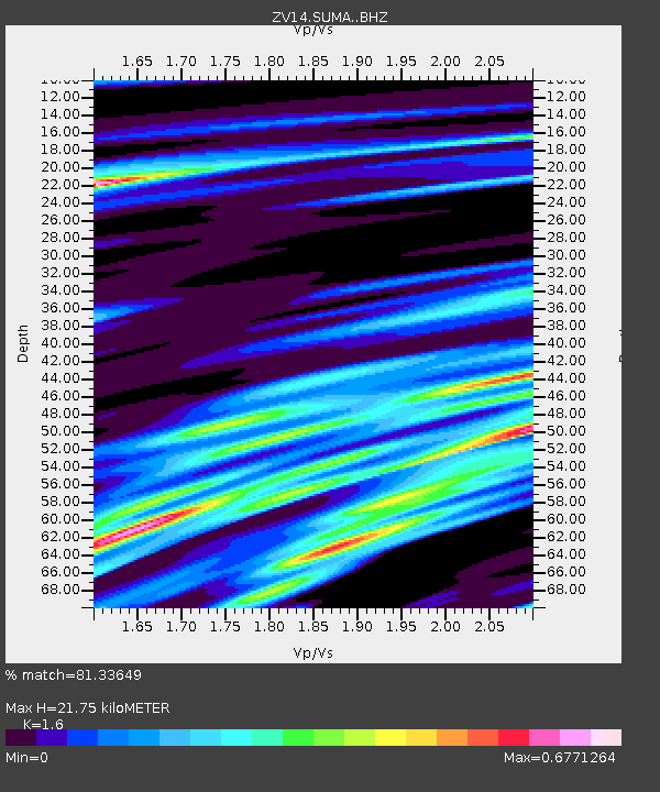
| Estimated Moho Depth: |
21.75 km |
| Estimated Crust Vp/Vs: |
1.60 |
| Assumed Crust Vp: |
6.502 km/s |
| Estimated Crust Vs: |
4.063 km/s |
| Estimated Crust Poisson's Ratio: |
0.18 |
|
| Radial Match: |
81.33649 % |
| Radial Bump: |
364 |
| Transverse Match: |
81.38755 % |
| Transverse Bump: |
400 |
| SOD ConfigId: |
7422571 |
| Insert Time: |
2019-04-19 14:35:20.511 +0000 |
| GWidth: |
2.5 |
| Max Bumps: |
400 |
| Tol: |
0.001 |
|

Signal To Noise
| Channel | StoN | STA | LTA |
| ZV:SUMA: :BHZ:20150703T01:17:38.43999Z | 8.538205 | 1.8073598E-6 | 2.1167912E-7 |
| ZV:SUMA: :BHN:20150703T01:17:38.43999Z | 2.7163272 | 7.562805E-7 | 2.7842023E-7 |
| ZV:SUMA: :BHE:20150703T01:17:38.43999Z | 3.7045214 | 5.3702024E-7 | 1.4496347E-7 |
| Arrivals |
| Ps | 2.1 SECOND |
| PpPs | 8.3 SECOND |
| PsPs/PpSs | 10 SECOND |


