You are here: Home > Network List > TA - USArray Transportable Network (new EarthScope stations) Stations List
> Station I64A Boothbay, ME, USA > Earthquake Result Viewer
I64A Boothbay, ME, USA - Earthquake Result Viewer
| Earthquake location: |
Southern Xinjiang, China |
| Earthquake latitude/longitude: |
37.4/78.0 |
| Earthquake time(UTC): |
2015/07/03 (184) 01:44:46 GMT |
| Earthquake Depth: |
28 km |
| Earthquake Magnitude: |
4.7 mb |
| Earthquake Catalog/Contributor: |
ISC/ISC |
|
| Network: |
TA USArray Transportable Network (new EarthScope stations) |
| Station: |
I64A Boothbay, ME, USA |
| Lat/Lon: |
43.92 N/69.63 W |
| Elevation: |
17 m |
|
| Distance: |
93.9 deg |
| Az: |
337.216 deg |
| Baz: |
25.274 deg |
| Ray Param: |
0.041148536 |
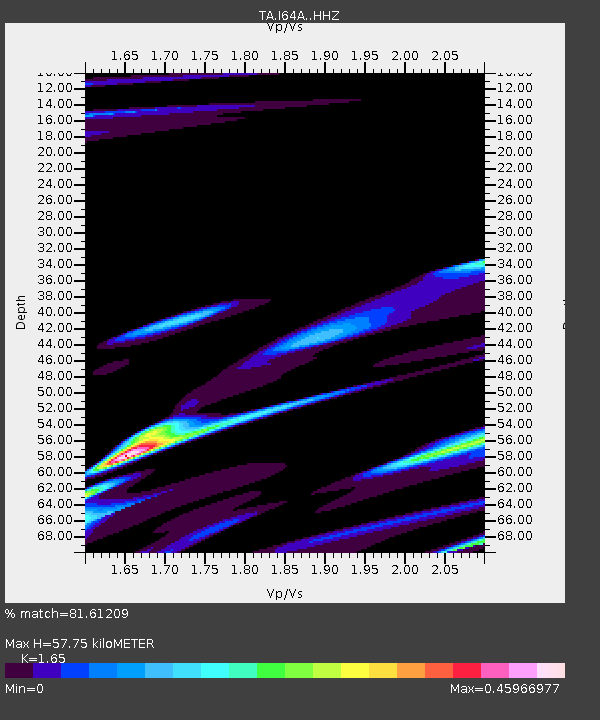
| Estimated Moho Depth: |
57.75 km |
| Estimated Crust Vp/Vs: |
1.65 |
| Assumed Crust Vp: |
6.419 km/s |
| Estimated Crust Vs: |
3.89 km/s |
| Estimated Crust Poisson's Ratio: |
0.21 |
|
| Radial Match: |
81.61209 % |
| Radial Bump: |
400 |
| Transverse Match: |
69.820145 % |
| Transverse Bump: |
400 |
| SOD ConfigId: |
7422571 |
| Insert Time: |
2019-04-19 14:38:53.193 +0000 |
| GWidth: |
2.5 |
| Max Bumps: |
400 |
| Tol: |
0.001 |
|
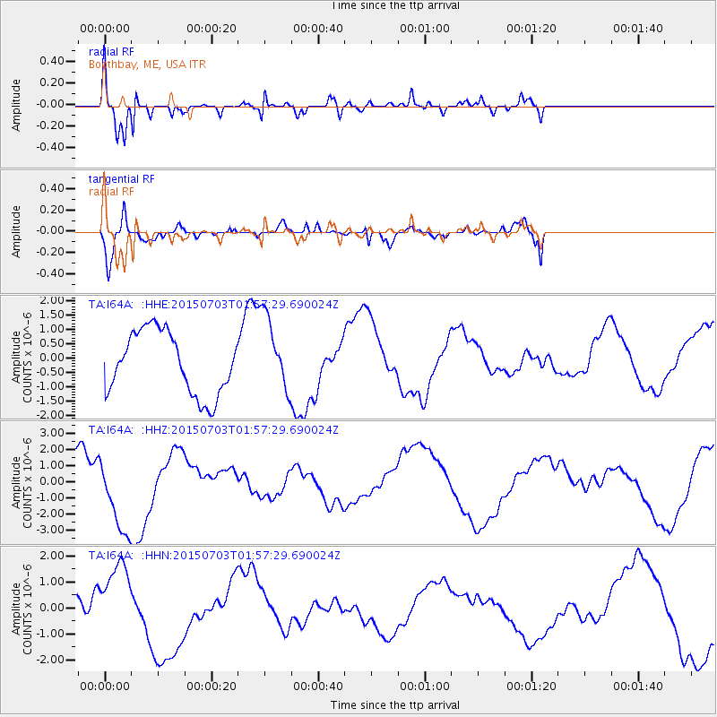
Signal To Noise
| Channel | StoN | STA | LTA |
| TA:I64A: :HHZ:20150703T01:57:29.690024Z | 2.2764955 | 2.4069918E-6 | 1.0573234E-6 |
| TA:I64A: :HHN:20150703T01:57:29.690024Z | 4.3790336 | 1.5365126E-6 | 3.508794E-7 |
| TA:I64A: :HHE:20150703T01:57:29.690024Z | 1.2338451 | 1.3463373E-6 | 1.0911721E-6 |
| Arrivals |
| Ps | 6.0 SECOND |
| PpPs | 23 SECOND |
| PsPs/PpSs | 29 SECOND |


