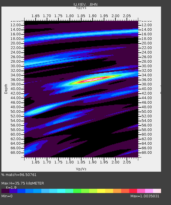
KIEV Kiev, Ukraine - Earthquake Result Viewer
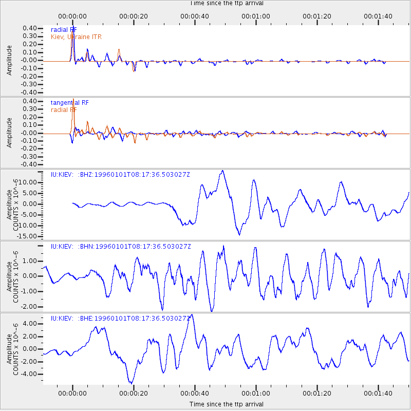
Earthquake location: Minahassa Peninsula, Sulawesi
Earthquake latitude/longitude: 0.7/120.0
Earthquake time(UTC): 1996/01/01 (001) 08:05:11 GMT
Earthquake Depth: 33 km
Earthquake Magnitude: 6.2 MB, 7.7 MS, 7.8 UNKNOWN, 7.8 MW
Earthquake Catalog/Contributor: WHDF/NEIC
Network: IU Global Seismograph Network (GSN - IRIS/USGS)
Station: KIEV Kiev, Ukraine
Lat/Lon: 50.69 N/29.21 E
Elevation: 163 m
Distance: 89.9 deg
Az: 320.51 deg
Baz: 88.946 deg
Ray Param: 0.041705173
Estimated Moho Depth: 35.75 km
Estimated Crust Vp/Vs: 1.90
Assumed Crust Vp: 6.552 km/s
Estimated Crust Vs: 3.449 km/s
Estimated Crust Poisson's Ratio: 0.31
Radial Match: 96.50761 %
Radial Bump: 270
Transverse Match: 79.07934 %
Transverse Bump: 400
SOD ConfigId: 6273
Insert Time: 2010-03-03 15:36:57.229 +0000
GWidth: 2.5
Max Bumps: 400
Tol: 0.001

Signal To Noise

ChannelStoNSTALTA
IU:KIEV: :BHN:19960101T08:17:36.503027Z0.193798789.547994E-84.9267567E-7
IU:KIEV: :BHE:19960101T08:17:36.503027Z2.0003066.248836E-73.1239404E-7
IU:KIEV: :BHZ:19960101T08:17:36.503027Z3.9731242.5738582E-66.478173E-7
Arrivals
Ps5.0 SECOND
PpPs16 SECOND
PsPs/PpSs21 SECOND