You are here: Home > Network List > IU - Global Seismograph Network (GSN - IRIS/USGS) Stations List
> Station KIEV Kiev, Ukraine > Earthquake Result Viewer
KIEV Kiev, Ukraine - Earthquake Result Viewer
| Earthquake location: |
Kuril Islands |
| Earthquake latitude/longitude: |
43.7/147.6 |
| Earthquake time(UTC): |
1996/05/07 (128) 23:20:00 GMT |
| Earthquake Depth: |
54 km |
| Earthquake Magnitude: |
6.2 MB, 5.6 MS, 6.2 UNKNOWN, 5.2 MS |
| Earthquake Catalog/Contributor: |
WHDF/NEIC |
|
| Network: |
IU Global Seismograph Network (GSN - IRIS/USGS) |
| Station: |
KIEV Kiev, Ukraine |
| Lat/Lon: |
50.69 N/29.21 E |
| Elevation: |
163 m |
|
| Distance: |
71.8 deg |
| Az: |
323.924 deg |
| Baz: |
42.178 deg |
| Ray Param: |
0.053962592 |
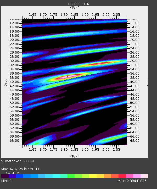
| Estimated Moho Depth: |
37.25 km |
| Estimated Crust Vp/Vs: |
1.82 |
| Assumed Crust Vp: |
6.552 km/s |
| Estimated Crust Vs: |
3.61 km/s |
| Estimated Crust Poisson's Ratio: |
0.28 |
|
| Radial Match: |
95.29969 % |
| Radial Bump: |
400 |
| Transverse Match: |
82.159355 % |
| Transverse Bump: |
400 |
| SOD ConfigId: |
6273 |
| Insert Time: |
2010-03-03 15:37:12.636 +0000 |
| GWidth: |
2.5 |
| Max Bumps: |
400 |
| Tol: |
0.001 |
|
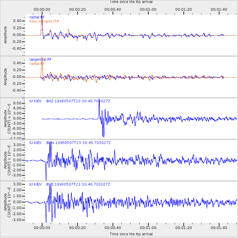
Signal To Noise
| Channel | StoN | STA | LTA |
| IU:KIEV: :BHN:19960507T23:30:46.703027Z | 26.334929 | 1.2917143E-6 | 4.904947E-8 |
| IU:KIEV: :BHE:19960507T23:30:46.703027Z | 8.197815 | 1.0815986E-6 | 1.3193741E-7 |
| IU:KIEV: :BHZ:19960507T23:30:46.703027Z | 58.525257 | 3.8245626E-6 | 6.534893E-8 |
| Arrivals |
| Ps | 4.8 SECOND |
| PpPs | 15 SECOND |
| PsPs/PpSs | 20 SECOND |


