KIEV Kiev, Ukraine - Earthquake Result Viewer
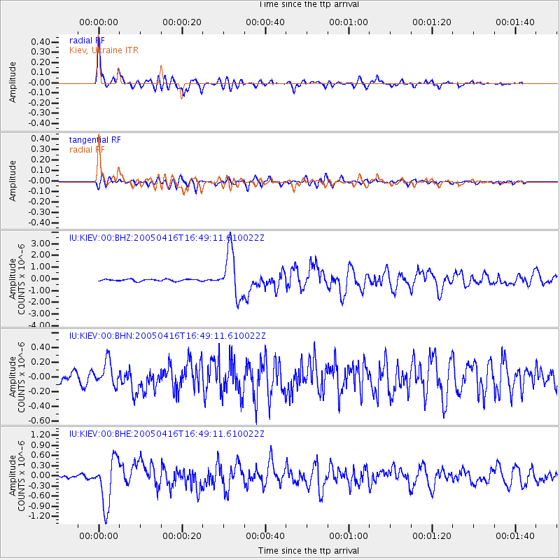
Earthquake location: Northern Sumatra, Indonesia
Earthquake latitude/longitude: 1.8/97.7
Earthquake time(UTC): 2005/04/16 (106) 16:38:03 GMT
Earthquake Depth: 31 km
Earthquake Magnitude: 6.0 MB, 6.2 MS, 6.4 MW, 6.3 MW
Earthquake Catalog/Contributor: WHDF/NEIC
Network: IU Global Seismograph Network (GSN - IRIS/USGS)
Station: KIEV Kiev, Ukraine
Lat/Lon: 50.69 N/29.21 E
Elevation: 163 m
Distance: 75.1 deg
Az: 322.249 deg
Baz: 105.813 deg
Ray Param: 0.05187232
Estimated Moho Depth: 38.75 km
Estimated Crust Vp/Vs: 1.77
Assumed Crust Vp: 6.552 km/s
Estimated Crust Vs: 3.692 km/s
Estimated Crust Poisson's Ratio: 0.27
Radial Match: 95.07053 %
Radial Bump: 400
Transverse Match: 85.8939 %
Transverse Bump: 400
SOD ConfigId: 2459
Insert Time: 2010-03-03 15:38:04.133 +0000
GWidth: 2.5
Max Bumps: 400
Tol: 0.001

Signal To Noise

ChannelStoNSTALTA
IU:KIEV:00:BHN:20050416T16:49:11.610022Z3.78060721.6765296E-74.4345512E-8
IU:KIEV:00:BHE:20050416T16:49:11.610022Z15.0289717.18829E-74.782956E-8
IU:KIEV:00:BHZ:20050416T16:49:11.610022Z26.1171252.0301475E-67.773242E-8
Arrivals
Ps4.7 SECOND
PpPs16 SECOND
PsPs/PpSs21 SECOND