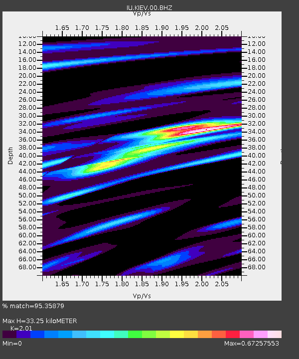
KIEV Kiev, Ukraine - Earthquake Result Viewer
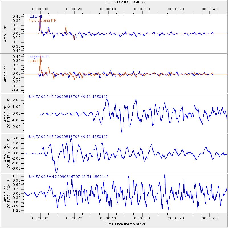
Earthquake location: Southern Sumatra, Indonesia
Earthquake latitude/longitude: -1.5/99.5
Earthquake time(UTC): 2009/08/16 (228) 07:38:21 GMT
Earthquake Depth: 20 km
Earthquake Magnitude: 6.5 MB, 6.7 MS, 6.7 MW, 6.5 MW
Earthquake Catalog/Contributor: WHDF/NEIC
Network: IU Global Seismograph Network (GSN - IRIS/USGS)
Station: KIEV Kiev, Ukraine
Lat/Lon: 50.70 N/29.22 E
Elevation: 180 m
Distance: 78.8 deg
Az: 322.392 deg
Baz: 106.393 deg
Ray Param: 0.049402516
Estimated Moho Depth: 33.25 km
Estimated Crust Vp/Vs: 2.01
Assumed Crust Vp: 6.552 km/s
Estimated Crust Vs: 3.26 km/s
Estimated Crust Poisson's Ratio: 0.34
Radial Match: 95.35879 %
Radial Bump: 383
Transverse Match: 88.29282 %
Transverse Bump: 400
SOD ConfigId: 2622
Insert Time: 2010-03-03 15:38:48.927 +0000
GWidth: 2.5
Max Bumps: 400
Tol: 0.001

Signal To Noise

ChannelStoNSTALTA
IU:KIEV:00:BHZ:20090816T07:49:51.486011Z5.1814861.0871122E-62.0980703E-7
IU:KIEV:00:BHN:20090816T07:49:51.486011Z1.1150281.238557E-71.11078556E-7
IU:KIEV:00:BHE:20090816T07:49:51.486011Z3.14661484.2970697E-71.3656167E-7
Arrivals
Ps5.3 SECOND
PpPs15 SECOND
PsPs/PpSs20 SECOND