You are here: Home > Network List > TA - USArray Transportable Network (new EarthScope stations) Stations List
> Station H21K Melozitna River, AK, USA > Earthquake Result Viewer
H21K Melozitna River, AK, USA - Earthquake Result Viewer
| Earthquake location: |
Leyte, Philippines |
| Earthquake latitude/longitude: |
10.2/125.9 |
| Earthquake time(UTC): |
2015/07/03 (184) 06:43:23 GMT |
| Earthquake Depth: |
50 km |
| Earthquake Magnitude: |
6.0 MB |
| Earthquake Catalog/Contributor: |
NEIC PDE/NEIC ALERT |
|
| Network: |
TA USArray Transportable Network (new EarthScope stations) |
| Station: |
H21K Melozitna River, AK, USA |
| Lat/Lon: |
65.66 N/152.80 W |
| Elevation: |
520 m |
|
| Distance: |
77.2 deg |
| Az: |
24.842 deg |
| Baz: |
266.26 deg |
| Ray Param: |
0.050393056 |
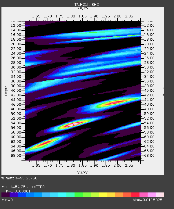
| Estimated Moho Depth: |
54.25 km |
| Estimated Crust Vp/Vs: |
1.81 |
| Assumed Crust Vp: |
6.566 km/s |
| Estimated Crust Vs: |
3.628 km/s |
| Estimated Crust Poisson's Ratio: |
0.28 |
|
| Radial Match: |
95.53756 % |
| Radial Bump: |
337 |
| Transverse Match: |
82.62918 % |
| Transverse Bump: |
400 |
| SOD ConfigId: |
7422571 |
| Insert Time: |
2019-04-19 14:59:51.739 +0000 |
| GWidth: |
2.5 |
| Max Bumps: |
400 |
| Tol: |
0.001 |
|

Signal To Noise
| Channel | StoN | STA | LTA |
| TA:H21K: :BHZ:20150703T06:54:40.425Z | 20.911873 | 1.8190749E-6 | 8.698766E-8 |
| TA:H21K: :BHN:20150703T06:54:40.425Z | 3.3757985 | 1.5700293E-7 | 4.6508386E-8 |
| TA:H21K: :BHE:20150703T06:54:40.425Z | 16.626923 | 8.7659794E-7 | 5.2721596E-8 |
| Arrivals |
| Ps | 6.9 SECOND |
| PpPs | 22 SECOND |
| PsPs/PpSs | 29 SECOND |


