You are here: Home > Network List > TA - USArray Transportable Network (new EarthScope stations) Stations List
> Station I23K Minto, Yukon-Koyukuk, AK, USA > Earthquake Result Viewer
I23K Minto, Yukon-Koyukuk, AK, USA - Earthquake Result Viewer
| Earthquake location: |
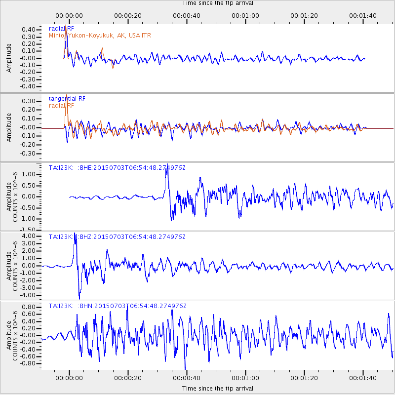
Leyte, Philippines |
| Earthquake latitude/longitude: |
10.2/125.9 |
| Earthquake time(UTC): |
2015/07/03 (184) 06:43:23 GMT |
| Earthquake Depth: |
50 km |
| Earthquake Magnitude: |
6.0 MB |
| Earthquake Catalog/Contributor: |
NEIC PDE/NEIC ALERT |
|
| Network: |
TA USArray Transportable Network (new EarthScope stations) |
| Station: |
I23K Minto, Yukon-Koyukuk, AK, USA |
| Lat/Lon: |
65.15 N/149.36 W |
| Elevation: |
149 m |
|
| Distance: |
78.6 deg |
| Az: |
25.419 deg |
| Baz: |
269.51 deg |
| Ray Param: |
0.049427755 |
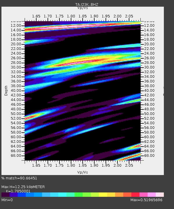
| Estimated Moho Depth: |
12.25 km |
| Estimated Crust Vp/Vs: |
1.79 |
| Assumed Crust Vp: |
6.566 km/s |
| Estimated Crust Vs: |
3.679 km/s |
| Estimated Crust Poisson's Ratio: |
0.27 |
|
| Radial Match: |
90.66451 % |
| Radial Bump: |
400 |
| Transverse Match: |
87.075455 % |
| Transverse Bump: |
400 |
| SOD ConfigId: |
7422571 |
| Insert Time: |
2019-04-19 14:59:56.259 +0000 |
| GWidth: |
2.5 |
| Max Bumps: |
400 |
| Tol: |
0.001 |
|
Signal To Noise
| Channel | StoN | STA | LTA |
| TA:I23K: :BHZ:20150703T06:54:48.274976Z | 34.229748 | 2.1433464E-6 | 6.2616486E-8 |
| TA:I23K: :BHN:20150703T06:54:48.274976Z | 4.756633 | 2.4440692E-7 | 5.138234E-8 |
| TA:I23K: :BHE:20150703T06:54:48.274976Z | 14.218036 | 6.642846E-7 | 4.672126E-8 |
| Arrivals |
| Ps | 1.5 SECOND |
| PpPs | 5.0 SECOND |
| PsPs/PpSs | 6.5 SECOND |


