You are here: Home > Network List > TA - USArray Transportable Network (new EarthScope stations) Stations List
> Station M20K Styx River, AK, USA > Earthquake Result Viewer
M20K Styx River, AK, USA - Earthquake Result Viewer
| Earthquake location: |
Leyte, Philippines |
| Earthquake latitude/longitude: |
10.2/125.9 |
| Earthquake time(UTC): |
2015/07/03 (184) 06:43:23 GMT |
| Earthquake Depth: |
50 km |
| Earthquake Magnitude: |
6.0 MB |
| Earthquake Catalog/Contributor: |
NEIC PDE/NEIC ALERT |
|
| Network: |
TA USArray Transportable Network (new EarthScope stations) |
| Station: |
M20K Styx River, AK, USA |
| Lat/Lon: |
61.88 N/153.13 W |
| Elevation: |
1107 m |
|
| Distance: |
76.8 deg |
| Az: |
28.716 deg |
| Baz: |
266.838 deg |
| Ray Param: |
0.050642505 |
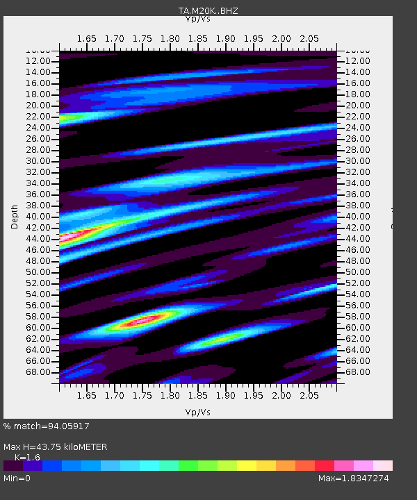
| Estimated Moho Depth: |
43.75 km |
| Estimated Crust Vp/Vs: |
1.60 |
| Assumed Crust Vp: |
6.566 km/s |
| Estimated Crust Vs: |
4.104 km/s |
| Estimated Crust Poisson's Ratio: |
0.18 |
|
| Radial Match: |
94.05917 % |
| Radial Bump: |
400 |
| Transverse Match: |
77.13495 % |
| Transverse Bump: |
400 |
| SOD ConfigId: |
7422571 |
| Insert Time: |
2019-04-19 15:00:01.384 +0000 |
| GWidth: |
2.5 |
| Max Bumps: |
400 |
| Tol: |
0.001 |
|

Signal To Noise
| Channel | StoN | STA | LTA |
| TA:M20K: :BHZ:20150703T06:54:38.325024Z | 46.515697 | 2.2343618E-6 | 4.8034575E-8 |
| TA:M20K: :BHN:20150703T06:54:38.325024Z | 2.4505563 | 3.500656E-7 | 1.4285148E-7 |
| TA:M20K: :BHE:20150703T06:54:38.325024Z | 11.408162 | 1.5357151E-6 | 1.3461548E-7 |
| Arrivals |
| Ps | 4.1 SECOND |
| PpPs | 17 SECOND |
| PsPs/PpSs | 21 SECOND |


