You are here: Home > Network List > TJ - Tajikistan National Seismic Network Stations List
> Station MANEM Manem, Tajikistan > Earthquake Result Viewer
MANEM Manem, Tajikistan - Earthquake Result Viewer
| Earthquake location: |
Leyte, Philippines |
| Earthquake latitude/longitude: |
10.2/125.9 |
| Earthquake time(UTC): |
2015/07/03 (184) 06:43:23 GMT |
| Earthquake Depth: |
50 km |
| Earthquake Magnitude: |
6.0 MB |
| Earthquake Catalog/Contributor: |
NEIC PDE/NEIC ALERT |
|
| Network: |
TJ Tajikistan National Seismic Network |
| Station: |
MANEM Manem, Tajikistan |
| Lat/Lon: |
37.53 N/71.66 E |
| Elevation: |
2312 m |
|
| Distance: |
55.7 deg |
| Az: |
308.633 deg |
| Baz: |
104.676 deg |
| Ray Param: |
0.0644932 |
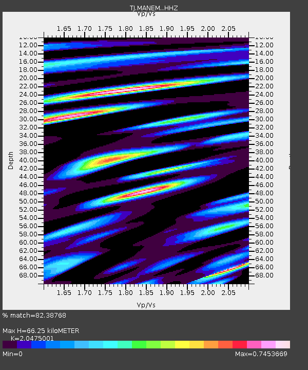
| Estimated Moho Depth: |
66.25 km |
| Estimated Crust Vp/Vs: |
2.05 |
| Assumed Crust Vp: |
6.306 km/s |
| Estimated Crust Vs: |
3.08 km/s |
| Estimated Crust Poisson's Ratio: |
0.34 |
|
| Radial Match: |
82.38768 % |
| Radial Bump: |
400 |
| Transverse Match: |
80.661255 % |
| Transverse Bump: |
400 |
| SOD ConfigId: |
7422571 |
| Insert Time: |
2019-04-19 15:00:14.028 +0000 |
| GWidth: |
2.5 |
| Max Bumps: |
400 |
| Tol: |
0.001 |
|

Signal To Noise
| Channel | StoN | STA | LTA |
| TJ:MANEM: :HHZ:20150703T06:52:23.859998Z | 28.761156 | 2.8265931E-6 | 9.827814E-8 |
| TJ:MANEM: :HHN:20150703T06:52:23.859998Z | 2.1163306 | 1.8679428E-7 | 8.826328E-8 |
| TJ:MANEM: :HHE:20150703T06:52:23.859998Z | 9.205509 | 1.1364713E-6 | 1.2345555E-7 |
| Arrivals |
| Ps | 11 SECOND |
| PpPs | 31 SECOND |
| PsPs/PpSs | 42 SECOND |


