You are here: Home > Network List > IU - Global Seismograph Network (GSN - IRIS/USGS) Stations List
> Station KIEV Kiev, Ukraine > Earthquake Result Viewer
KIEV Kiev, Ukraine - Earthquake Result Viewer

| Earthquake location: |
Kuril Islands |
| Earthquake latitude/longitude: |
46.6/153.3 |
| Earthquake time(UTC): |
2006/11/15 (319) 11:14:13 GMT |
| Earthquake Depth: |
10 km |
| Earthquake Magnitude: |
6.5 MB, 7.8 MS, 8.3 MW, 7.9 MW |
| Earthquake Catalog/Contributor: |
WHDF/NEIC |
|
| Network: |
IU Global Seismograph Network (GSN - IRIS/USGS) |
| Station: |
KIEV Kiev, Ukraine |
| Lat/Lon: |
50.69 N/29.21 E |
| Elevation: |
163 m |
|
| Distance: |
71.7 deg |
| Az: |
326.301 deg |
| Baz: |
36.985 deg |
| Ray Param: |
0.054121375 |
| Estimated Moho Depth: |
37.75 km |
| Estimated Crust Vp/Vs: |
1.80 |
| Assumed Crust Vp: |
6.552 km/s |
| Estimated Crust Vs: |
3.64 km/s |
| Estimated Crust Poisson's Ratio: |
0.28 |
|
| Radial Match: |
98.44941 % |
| Radial Bump: |
342 |
| Transverse Match: |
94.97343 % |
| Transverse Bump: |
400 |
| SOD ConfigId: |
2564 |
| Insert Time: |
2010-03-03 15:41:27.829 +0000 |
| GWidth: |
2.5 |
| Max Bumps: |
400 |
| Tol: |
0.001 |
|
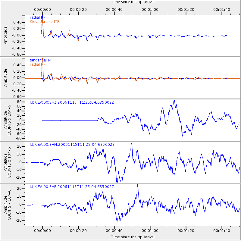
Signal To Noise
| Channel | StoN | STA | LTA |
| IU:KIEV:00:BHN:20061115T11:25:04.635002Z | 6.9451995 | 2.0431755E-6 | 2.9418527E-7 |
| IU:KIEV:00:BHE:20061115T11:25:04.635002Z | 2.9061759 | 1.129721E-6 | 3.887311E-7 |
| IU:KIEV:00:BHZ:20061115T11:25:04.635002Z | 10.708203 | 5.4786906E-6 | 5.1163494E-7 |
| Arrivals |
| Ps | 4.8 SECOND |
| PpPs | 16 SECOND |
| PsPs/PpSs | 20 SECOND |


