You are here: Home > Network List > IU - Global Seismograph Network (GSN - IRIS/USGS) Stations List
> Station KIEV Kiev, Ukraine > Earthquake Result Viewer
KIEV Kiev, Ukraine - Earthquake Result Viewer
| Earthquake location: |
South Of Java, Indonesia |
| Earthquake latitude/longitude: |
-9.3/107.4 |
| Earthquake time(UTC): |
2006/07/17 (198) 08:19:28 GMT |
| Earthquake Depth: |
34 km |
| Earthquake Magnitude: |
6.1 MB, 7.2 MS, 7.7 MW, 7.2 MW |
| Earthquake Catalog/Contributor: |
WHDF/NEIC |
|
| Network: |
IU Global Seismograph Network (GSN - IRIS/USGS) |
| Station: |
KIEV Kiev, Ukraine |
| Lat/Lon: |
50.69 N/29.21 E |
| Elevation: |
163 m |
|
| Distance: |
89.7 deg |
| Az: |
321.496 deg |
| Baz: |
104.913 deg |
| Ray Param: |
0.041721188 |
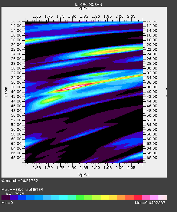
| Estimated Moho Depth: |
38.0 km |
| Estimated Crust Vp/Vs: |
1.80 |
| Assumed Crust Vp: |
6.552 km/s |
| Estimated Crust Vs: |
3.645 km/s |
| Estimated Crust Poisson's Ratio: |
0.28 |
|
| Radial Match: |
96.51762 % |
| Radial Bump: |
400 |
| Transverse Match: |
86.29222 % |
| Transverse Bump: |
400 |
| SOD ConfigId: |
5423 |
| Insert Time: |
2010-03-03 15:41:41.494 +0000 |
| GWidth: |
2.5 |
| Max Bumps: |
400 |
| Tol: |
0.001 |
|
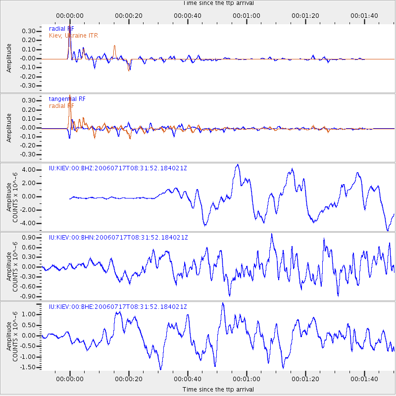
Signal To Noise
| Channel | StoN | STA | LTA |
| IU:KIEV:00:BHN:20060717T08:31:52.184021Z | 1.6825958 | 8.737597E-8 | 5.192927E-8 |
| IU:KIEV:00:BHE:20060717T08:31:52.184021Z | 3.6838212 | 2.4611126E-7 | 6.680869E-8 |
| IU:KIEV:00:BHZ:20060717T08:31:52.184021Z | 11.717532 | 7.8738975E-7 | 6.7197576E-8 |
| Arrivals |
| Ps | 4.7 SECOND |
| PpPs | 16 SECOND |
| PsPs/PpSs | 21 SECOND |


