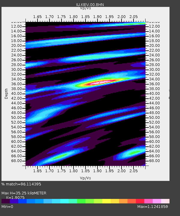
KIEV Kiev, Ukraine - Earthquake Result Viewer
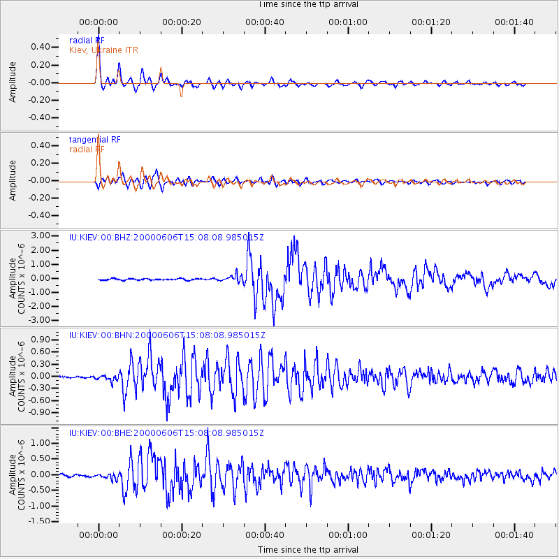
Earthquake location: Southeast Of Ryukyu Islands
Earthquake latitude/longitude: 29.4/131.4
Earthquake time(UTC): 2000/06/06 (158) 14:57:02 GMT
Earthquake Depth: 33 km
Earthquake Magnitude: 5.8 MB, 6.0 MS, 6.4 MW, 6.4 MW
Earthquake Catalog/Contributor: WHDF/NEIC
Network: IU Global Seismograph Network (GSN - IRIS/USGS)
Station: KIEV Kiev, Ukraine
Lat/Lon: 50.69 N/29.21 E
Elevation: 163 m
Distance: 74.9 deg
Az: 319.931 deg
Baz: 62.005 deg
Ray Param: 0.051948704
Estimated Moho Depth: 35.25 km
Estimated Crust Vp/Vs: 1.91
Assumed Crust Vp: 6.552 km/s
Estimated Crust Vs: 3.435 km/s
Estimated Crust Poisson's Ratio: 0.31
Radial Match: 96.114395 %
Radial Bump: 356
Transverse Match: 89.79719 %
Transverse Bump: 400
SOD ConfigId: 3744
Insert Time: 2010-03-03 15:42:51.175 +0000
GWidth: 2.5
Max Bumps: 400
Tol: 0.001

Signal To Noise

ChannelStoNSTALTA
IU:KIEV:00:BHN:20000606T15:08:08.985015Z2.2710567.24881E-83.1918233E-8
IU:KIEV:00:BHE:20000606T15:08:08.985015Z2.30485778.7225665E-83.7844273E-8
IU:KIEV:00:BHZ:20000606T15:08:08.985015Z4.72444872.4225787E-75.127749E-8
Arrivals
Ps5.0 SECOND
PpPs15 SECOND
PsPs/PpSs20 SECOND