You are here: Home > Network List > US - United States National Seismic Network Stations List
> Station MSO Missoula, Montana, USA > Earthquake Result Viewer
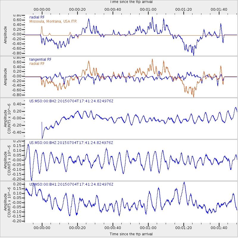
MSO Missoula, Montana, USA - Earthquake Result Viewer
*The percent match for this event was below the threshold and hence no stack was calculated.
| Earthquake location: |
South Of Kermadec Islands |
| Earthquake latitude/longitude: |
-32.1/-177.9 |
| Earthquake time(UTC): |
2015/07/04 (185) 17:28:25 GMT |
| Earthquake Depth: |
24 km |
| Earthquake Magnitude: |
5.2 MW |
| Earthquake Catalog/Contributor: |
ISC/ISC |
|
| Network: |
US United States National Seismic Network |
| Station: |
MSO Missoula, Montana, USA |
| Lat/Lon: |
46.83 N/113.94 W |
| Elevation: |
1264 m |
|
| Distance: |
97.4 deg |
| Az: |
38.485 deg |
| Baz: |
230.29 deg |
| Ray Param: |
$rayparam |
*The percent match for this event was below the threshold and hence was not used in the summary stack. |
|
| Radial Match: |
28.191566 % |
| Radial Bump: |
400 |
| Transverse Match: |
56.204227 % |
| Transverse Bump: |
400 |
| SOD ConfigId: |
7422571 |
| Insert Time: |
2019-04-19 15:15:39.227 +0000 |
| GWidth: |
2.5 |
| Max Bumps: |
400 |
| Tol: |
0.001 |
|
Signal To Noise
| Channel | StoN | STA | LTA |
| US:MSO:00:BHZ:20150704T17:41:24.824976Z | 0.80604666 | 6.771712E-8 | 8.401141E-8 |
| US:MSO:00:BH1:20150704T17:41:24.824976Z | 0.7740333 | 1.4630461E-7 | 1.8901592E-7 |
| US:MSO:00:BH2:20150704T17:41:24.824976Z | 0.5980675 | 1.09457794E-7 | 1.8301913E-7 |
| Arrivals |
| Ps | |
| PpPs | |
| PsPs/PpSs | |


