You are here: Home > Network List > JP - Japan Meteorological Agency Seismic Network Stations List
> Station JGF Gifu Kurokawa > Earthquake Result Viewer
JGF Gifu Kurokawa - Earthquake Result Viewer
| Earthquake location: |
Andreanof Islands, Aleutian Is. |
| Earthquake latitude/longitude: |
51.5/-173.8 |
| Earthquake time(UTC): |
2015/07/04 (185) 23:35:53 GMT |
| Earthquake Depth: |
29 km |
| Earthquake Magnitude: |
5.1 MW |
| Earthquake Catalog/Contributor: |
ISC/ISC |
|
| Network: |
JP Japan Meteorological Agency Seismic Network |
| Station: |
JGF Gifu Kurokawa |
| Lat/Lon: |
35.60 N/137.35 E |
| Elevation: |
580 m |
|
| Distance: |
38.0 deg |
| Az: |
264.69 deg |
| Baz: |
49.76 deg |
| Ray Param: |
0.07575412 |
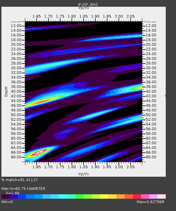
| Estimated Moho Depth: |
65.75 km |
| Estimated Crust Vp/Vs: |
1.66 |
| Assumed Crust Vp: |
6.461 km/s |
| Estimated Crust Vs: |
3.892 km/s |
| Estimated Crust Poisson's Ratio: |
0.22 |
|
| Radial Match: |
91.41127 % |
| Radial Bump: |
246 |
| Transverse Match: |
55.373688 % |
| Transverse Bump: |
400 |
| SOD ConfigId: |
7422571 |
| Insert Time: |
2019-04-19 15:19:58.851 +0000 |
| GWidth: |
2.5 |
| Max Bumps: |
400 |
| Tol: |
0.001 |
|

Signal To Noise
| Channel | StoN | STA | LTA |
| JP:JGF: :BHZ:20150704T23:42:38.600004Z | 2.0917044 | 2.1168825E-7 | 1.0120372E-7 |
| JP:JGF: :BHN:20150704T23:42:38.600004Z | 1.586932 | 1.0833252E-7 | 6.8265386E-8 |
| JP:JGF: :BHE:20150704T23:42:38.600004Z | 1.8118335 | 1.6858019E-7 | 9.304398E-8 |
| Arrivals |
| Ps | 7.3 SECOND |
| PpPs | 25 SECOND |
| PsPs/PpSs | 32 SECOND |


