You are here: Home > Network List > TA - USArray Transportable Network (new EarthScope stations) Stations List
> Station R11A Troy Canyon, Currant, NV, USA > Earthquake Result Viewer
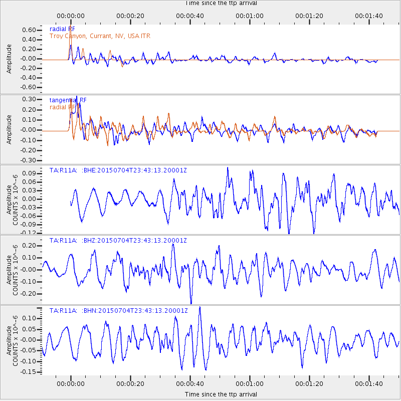
R11A Troy Canyon, Currant, NV, USA - Earthquake Result Viewer
*The percent match for this event was below the threshold and hence no stack was calculated.
| Earthquake location: |
Andreanof Islands, Aleutian Is. |
| Earthquake latitude/longitude: |
51.5/-173.8 |
| Earthquake time(UTC): |
2015/07/04 (185) 23:35:53 GMT |
| Earthquake Depth: |
29 km |
| Earthquake Magnitude: |
5.1 MW |
| Earthquake Catalog/Contributor: |
ISC/ISC |
|
| Network: |
TA USArray Transportable Network (new EarthScope stations) |
| Station: |
R11A Troy Canyon, Currant, NV, USA |
| Lat/Lon: |
38.35 N/115.59 W |
| Elevation: |
1756 m |
|
| Distance: |
42.2 deg |
| Az: |
84.618 deg |
| Baz: |
307.716 deg |
| Ray Param: |
$rayparam |
*The percent match for this event was below the threshold and hence was not used in the summary stack. |
|
| Radial Match: |
54.64311 % |
| Radial Bump: |
400 |
| Transverse Match: |
65.24545 % |
| Transverse Bump: |
400 |
| SOD ConfigId: |
7422571 |
| Insert Time: |
2019-04-19 15:23:21.997 +0000 |
| GWidth: |
2.5 |
| Max Bumps: |
400 |
| Tol: |
0.001 |
|
Signal To Noise
| Channel | StoN | STA | LTA |
| TA:R11A: :BHZ:20150704T23:43:13.20001Z | 2.7256477 | 9.816939E-8 | 3.60169E-8 |
| TA:R11A: :BHN:20150704T23:43:13.20001Z | 1.0781363 | 5.6989226E-8 | 5.2859015E-8 |
| TA:R11A: :BHE:20150704T23:43:13.20001Z | 1.5680065 | 4.463716E-8 | 2.846746E-8 |
| Arrivals |
| Ps | |
| PpPs | |
| PsPs/PpSs | |


