You are here: Home > Network List > TA - USArray Transportable Network (new EarthScope stations) Stations List
> Station X43A Marvell, AR, USA > Earthquake Result Viewer
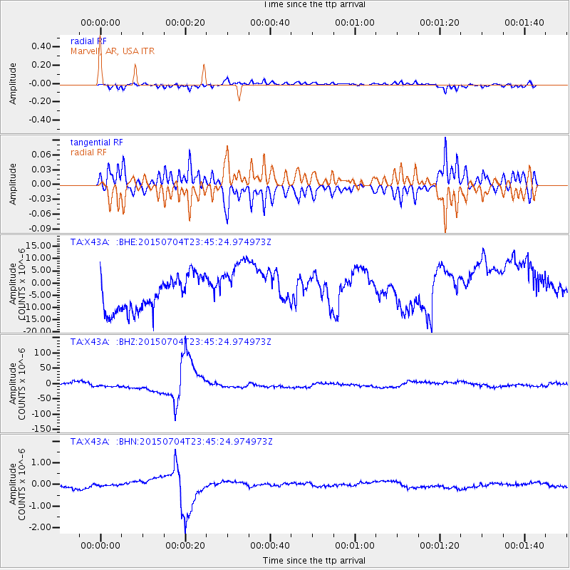
X43A Marvell, AR, USA - Earthquake Result Viewer
*The percent match for this event was below the threshold and hence no stack was calculated.
| Earthquake location: |
Andreanof Islands, Aleutian Is. |
| Earthquake latitude/longitude: |
51.5/-173.8 |
| Earthquake time(UTC): |
2015/07/04 (185) 23:35:53 GMT |
| Earthquake Depth: |
29 km |
| Earthquake Magnitude: |
5.1 MW |
| Earthquake Catalog/Contributor: |
ISC/ISC |
|
| Network: |
TA USArray Transportable Network (new EarthScope stations) |
| Station: |
X43A Marvell, AR, USA |
| Lat/Lon: |
34.52 N/90.88 W |
| Elevation: |
53 m |
|
| Distance: |
59.8 deg |
| Az: |
71.552 deg |
| Baz: |
314.134 deg |
| Ray Param: |
$rayparam |
*The percent match for this event was below the threshold and hence was not used in the summary stack. |
|
| Radial Match: |
59.00649 % |
| Radial Bump: |
400 |
| Transverse Match: |
59.16474 % |
| Transverse Bump: |
400 |
| SOD ConfigId: |
7422571 |
| Insert Time: |
2019-04-19 15:23:25.213 +0000 |
| GWidth: |
2.5 |
| Max Bumps: |
400 |
| Tol: |
0.001 |
|
Signal To Noise
| Channel | StoN | STA | LTA |
| TA:X43A: :BHZ:20150704T23:45:24.974973Z | 1.3042778 | 8.225293E-6 | 6.3063967E-6 |
| TA:X43A: :BHN:20150704T23:45:24.974973Z | 0.3654033 | 2.8083049E-8 | 7.685494E-8 |
| TA:X43A: :BHE:20150704T23:45:24.974973Z | 1.7602832 | 1.1746008E-5 | 6.672794E-6 |
| Arrivals |
| Ps | |
| PpPs | |
| PsPs/PpSs | |


