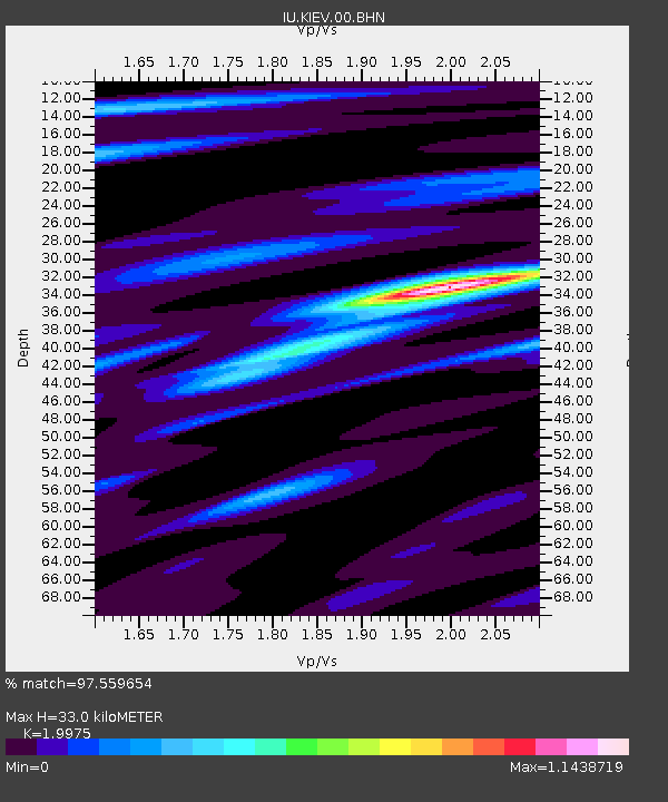
KIEV Kiev, Ukraine - Earthquake Result Viewer
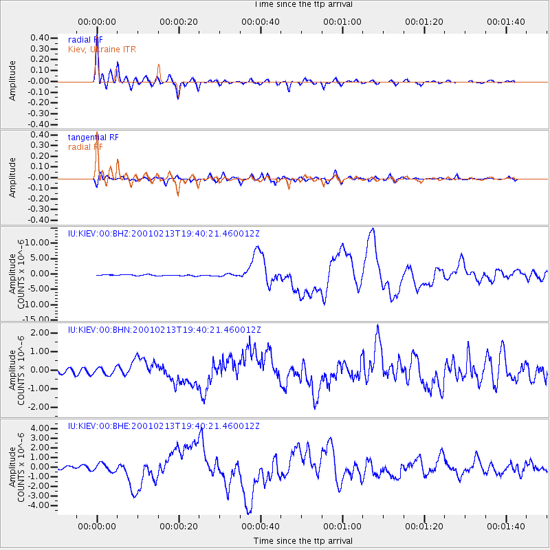
Earthquake location: Southern Sumatra, Indonesia
Earthquake latitude/longitude: -4.7/102.6
Earthquake time(UTC): 2001/02/13 (044) 19:28:30 GMT
Earthquake Depth: 36 km
Earthquake Magnitude: 6.2 MB, 7.2 MS, 7.4 MW, 7.0 ME
Earthquake Catalog/Contributor: WHDF/NEIC
Network: IU Global Seismograph Network (GSN - IRIS/USGS)
Station: KIEV Kiev, Ukraine
Lat/Lon: 50.69 N/29.21 E
Elevation: 163 m
Distance: 83.2 deg
Az: 322.142 deg
Baz: 105.892 deg
Ray Param: 0.04633332
Estimated Moho Depth: 33.0 km
Estimated Crust Vp/Vs: 2.00
Assumed Crust Vp: 6.552 km/s
Estimated Crust Vs: 3.28 km/s
Estimated Crust Poisson's Ratio: 0.33
Radial Match: 97.559654 %
Radial Bump: 400
Transverse Match: 89.98629 %
Transverse Bump: 400
SOD ConfigId: 3744
Insert Time: 2010-03-03 15:44:05.323 +0000
GWidth: 2.5
Max Bumps: 400
Tol: 0.001

Signal To Noise

ChannelStoNSTALTA
IU:KIEV:00:BHN:20010213T19:40:21.460012Z1.84989421.8635426E-71.0073779E-7
IU:KIEV:00:BHE:20010213T19:40:21.460012Z2.68202474.0517557E-71.5107078E-7
IU:KIEV:00:BHZ:20010213T19:40:21.460012Z1.97866273.3664926E-71.7013978E-7
Arrivals
Ps5.1 SECOND
PpPs15 SECOND
PsPs/PpSs20 SECOND