KIEV Kiev, Ukraine - Earthquake Result Viewer
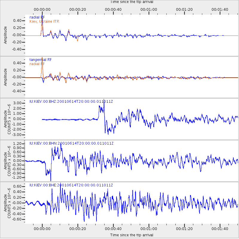
Earthquake location: Andreanof Islands, Aleutian Is.
Earthquake latitude/longitude: 51.2/-179.8
Earthquake time(UTC): 2001/06/14 (165) 19:48:47 GMT
Earthquake Depth: 18 km
Earthquake Magnitude: 6.0 MB, 6.3 MS, 6.5 MW, 6.1 ML
Earthquake Catalog/Contributor: WHDF/NEIC
Network: IU Global Seismograph Network (GSN - IRIS/USGS)
Station: KIEV Kiev, Ukraine
Lat/Lon: 50.69 N/29.21 E
Elevation: 163 m
Distance: 75.6 deg
Az: 341.412 deg
Baz: 18.397 deg
Ray Param: 0.05156955
Estimated Moho Depth: 23.75 km
Estimated Crust Vp/Vs: 1.89
Assumed Crust Vp: 6.552 km/s
Estimated Crust Vs: 3.467 km/s
Estimated Crust Poisson's Ratio: 0.31
Radial Match: 96.10781 %
Radial Bump: 384
Transverse Match: 90.07796 %
Transverse Bump: 400
SOD ConfigId: 4714
Insert Time: 2010-03-03 15:44:16.571 +0000
GWidth: 2.5
Max Bumps: 400
Tol: 0.001

Signal To Noise

ChannelStoNSTALTA
IU:KIEV:00:BHN:20010614T20:00:00.011011Z21.6544176.045715E-72.7919084E-8
IU:KIEV:00:BHE:20010614T20:00:00.011011Z4.1750971.4481931E-73.4686455E-8
IU:KIEV:00:BHZ:20010614T20:00:00.011011Z31.9550171.522624E-64.7648978E-8
Arrivals
Ps3.3 SECOND
PpPs10 SECOND
PsPs/PpSs13 SECOND