You are here: Home > Network List > US - United States National Seismic Network Stations List
> Station MSO Missoula, Montana, USA > Earthquake Result Viewer
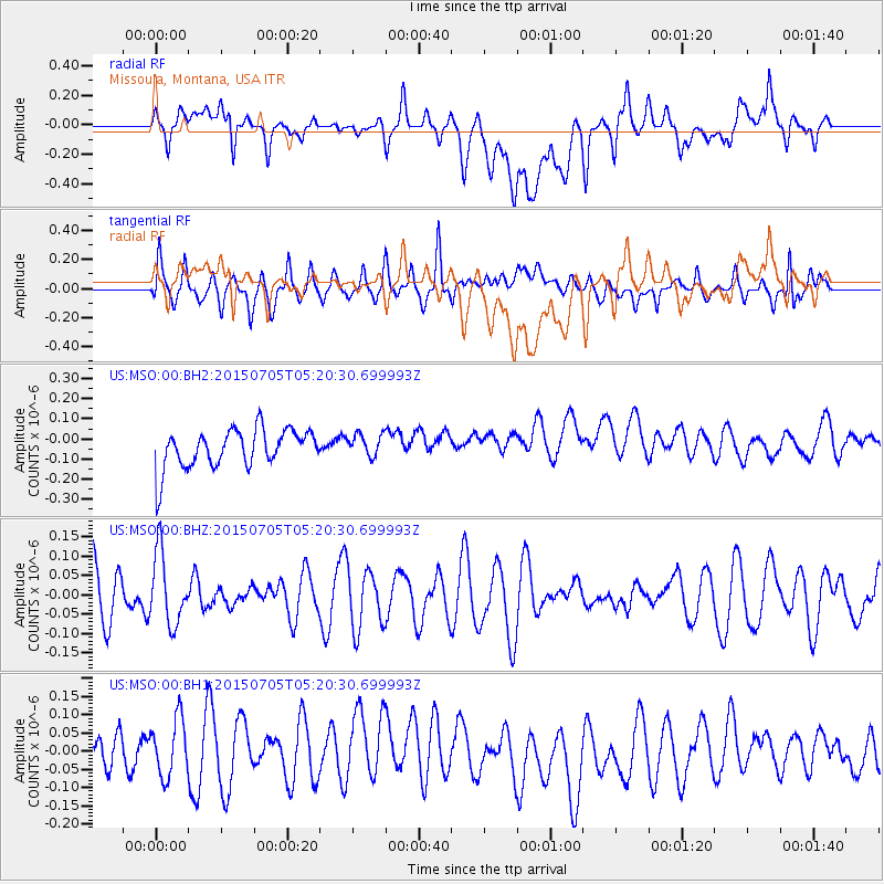
MSO Missoula, Montana, USA - Earthquake Result Viewer
*The percent match for this event was below the threshold and hence no stack was calculated.
| Earthquake location: |
Southeast Of Loyalty Islands |
| Earthquake latitude/longitude: |
-22.4/171.8 |
| Earthquake time(UTC): |
2015/07/05 (186) 05:07:46 GMT |
| Earthquake Depth: |
100 km |
| Earthquake Magnitude: |
5.2 MW |
| Earthquake Catalog/Contributor: |
ISC/ISC |
|
| Network: |
US United States National Seismic Network |
| Station: |
MSO Missoula, Montana, USA |
| Lat/Lon: |
46.83 N/113.94 W |
| Elevation: |
1264 m |
|
| Distance: |
95.9 deg |
| Az: |
41.649 deg |
| Baz: |
243.628 deg |
| Ray Param: |
$rayparam |
*The percent match for this event was below the threshold and hence was not used in the summary stack. |
|
| Radial Match: |
56.101967 % |
| Radial Bump: |
400 |
| Transverse Match: |
50.946968 % |
| Transverse Bump: |
400 |
| SOD ConfigId: |
7422571 |
| Insert Time: |
2019-04-19 15:29:49.357 +0000 |
| GWidth: |
2.5 |
| Max Bumps: |
400 |
| Tol: |
0.001 |
|
Signal To Noise
| Channel | StoN | STA | LTA |
| US:MSO:00:BHZ:20150705T05:20:30.699993Z | 1.327023 | 9.24585E-8 | 6.9673625E-8 |
| US:MSO:00:BH1:20150705T05:20:30.699993Z | 1.0800803 | 9.4891E-8 | 8.7855504E-8 |
| US:MSO:00:BH2:20150705T05:20:30.699993Z | 0.5941049 | 5.6877983E-8 | 9.573728E-8 |
| Arrivals |
| Ps | |
| PpPs | |
| PsPs/PpSs | |


