You are here: Home > Network List > TA - USArray Transportable Network (new EarthScope stations) Stations List
> Station MSTX Muleshoe, TX, USA > Earthquake Result Viewer
MSTX Muleshoe, TX, USA - Earthquake Result Viewer
| Earthquake location: |
Tonga Islands |
| Earthquake latitude/longitude: |
-20.8/-174.5 |
| Earthquake time(UTC): |
2015/07/06 (187) 12:24:00 GMT |
| Earthquake Depth: |
1.0 km |
| Earthquake Magnitude: |
6.2 MO |
| Earthquake Catalog/Contributor: |
NEIC PDE/NEIC ALERT |
|
| Network: |
TA USArray Transportable Network (new EarthScope stations) |
| Station: |
MSTX Muleshoe, TX, USA |
| Lat/Lon: |
33.97 N/102.77 W |
| Elevation: |
1167 m |
|
| Distance: |
87.3 deg |
| Az: |
52.181 deg |
| Baz: |
242.8 deg |
| Ray Param: |
0.04347157 |
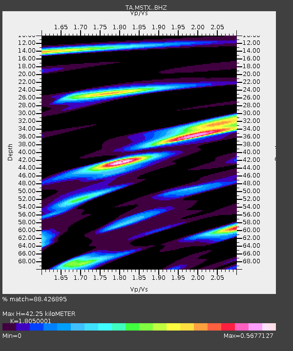
| Estimated Moho Depth: |
42.25 km |
| Estimated Crust Vp/Vs: |
1.81 |
| Assumed Crust Vp: |
6.129 km/s |
| Estimated Crust Vs: |
3.396 km/s |
| Estimated Crust Poisson's Ratio: |
0.28 |
|
| Radial Match: |
88.426895 % |
| Radial Bump: |
354 |
| Transverse Match: |
66.28908 % |
| Transverse Bump: |
400 |
| SOD ConfigId: |
7422571 |
| Insert Time: |
2019-04-19 15:49:55.950 +0000 |
| GWidth: |
2.5 |
| Max Bumps: |
400 |
| Tol: |
0.001 |
|
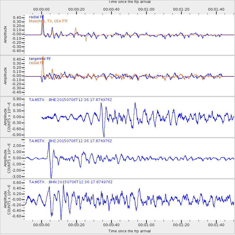
Signal To Noise
| Channel | StoN | STA | LTA |
| TA:MSTX: :BHZ:20150706T12:36:17.874976Z | 8.367177 | 8.156324E-7 | 9.748E-8 |
| TA:MSTX: :BHN:20150706T12:36:17.874976Z | 1.9352096 | 2.0385758E-7 | 1.0534134E-7 |
| TA:MSTX: :BHE:20150706T12:36:17.874976Z | 3.2643027 | 2.6766497E-7 | 8.19976E-8 |
| Arrivals |
| Ps | 5.7 SECOND |
| PpPs | 19 SECOND |
| PsPs/PpSs | 25 SECOND |


