You are here: Home > Network List > TA - USArray Transportable Network (new EarthScope stations) Stations List
> Station W41B Gary Mavity, Velonia, AR, USA > Earthquake Result Viewer
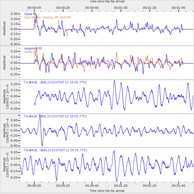
W41B Gary Mavity, Velonia, AR, USA - Earthquake Result Viewer
*The percent match for this event was below the threshold and hence no stack was calculated.
| Earthquake location: |
Tonga Islands |
| Earthquake latitude/longitude: |
-20.8/-174.5 |
| Earthquake time(UTC): |
2015/07/06 (187) 12:24:00 GMT |
| Earthquake Depth: |
1.0 km |
| Earthquake Magnitude: |
6.2 MO |
| Earthquake Catalog/Contributor: |
NEIC PDE/NEIC ALERT |
|
| Network: |
TA USArray Transportable Network (new EarthScope stations) |
| Station: |
W41B Gary Mavity, Velonia, AR, USA |
| Lat/Lon: |
35.17 N/92.25 W |
| Elevation: |
95 m |
|
| Distance: |
95.7 deg |
| Az: |
54.654 deg |
| Baz: |
248.693 deg |
| Ray Param: |
$rayparam |
*The percent match for this event was below the threshold and hence was not used in the summary stack. |
|
| Radial Match: |
73.54421 % |
| Radial Bump: |
400 |
| Transverse Match: |
60.32999 % |
| Transverse Bump: |
365 |
| SOD ConfigId: |
7422571 |
| Insert Time: |
2019-04-19 15:50:16.448 +0000 |
| GWidth: |
2.5 |
| Max Bumps: |
400 |
| Tol: |
0.001 |
|
Signal To Noise
| Channel | StoN | STA | LTA |
| TA:W41B: :BHZ:20150706T12:36:56.775Z | 2.2005544 | 2.5747812E-7 | 1.17006024E-7 |
| TA:W41B: :BHN:20150706T12:36:56.775Z | 1.2496719 | 7.758435E-8 | 6.208378E-8 |
| TA:W41B: :BHE:20150706T12:36:56.775Z | 1.5435926 | 7.6459145E-8 | 4.953324E-8 |
| Arrivals |
| Ps | |
| PpPs | |
| PsPs/PpSs | |


