You are here: Home > Network List > UW - Pacific Northwest Regional Seismic Network Stations List
> Station PASS Maple Falls, WA, USA > Earthquake Result Viewer
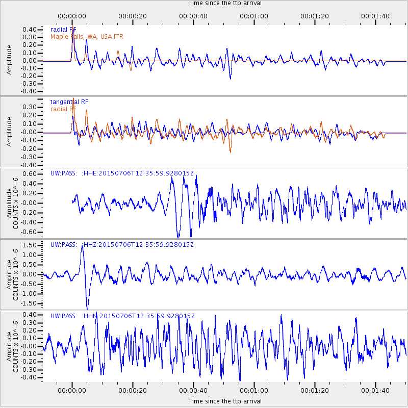
PASS Maple Falls, WA, USA - Earthquake Result Viewer
*The percent match for this event was below the threshold and hence no stack was calculated.
| Earthquake location: |
Tonga Islands |
| Earthquake latitude/longitude: |
-20.8/-174.5 |
| Earthquake time(UTC): |
2015/07/06 (187) 12:24:00 GMT |
| Earthquake Depth: |
1.0 km |
| Earthquake Magnitude: |
6.2 MO |
| Earthquake Catalog/Contributor: |
NEIC PDE/NEIC ALERT |
|
| Network: |
UW Pacific Northwest Regional Seismic Network |
| Station: |
PASS Maple Falls, WA, USA |
| Lat/Lon: |
49.00 N/122.09 W |
| Elevation: |
174 m |
|
| Distance: |
83.6 deg |
| Az: |
31.664 deg |
| Baz: |
228.23 deg |
| Ray Param: |
$rayparam |
*The percent match for this event was below the threshold and hence was not used in the summary stack. |
|
| Radial Match: |
78.774315 % |
| Radial Bump: |
400 |
| Transverse Match: |
74.003624 % |
| Transverse Bump: |
400 |
| SOD ConfigId: |
7422571 |
| Insert Time: |
2019-04-19 15:51:22.930 +0000 |
| GWidth: |
2.5 |
| Max Bumps: |
400 |
| Tol: |
0.001 |
|
Signal To Noise
| Channel | StoN | STA | LTA |
| UW:PASS: :HHZ:20150706T12:35:59.928015Z | 6.0618033 | 6.894717E-7 | 1.1374036E-7 |
| UW:PASS: :HHN:20150706T12:35:59.928015Z | 1.3222848 | 1.1985617E-7 | 9.064324E-8 |
| UW:PASS: :HHE:20150706T12:35:59.928015Z | 2.9229014 | 2.62745E-7 | 8.989185E-8 |
| Arrivals |
| Ps | |
| PpPs | |
| PsPs/PpSs | |


