You are here: Home > Network List > XD14 - Illuminating the architecture of the greater Mount St. Helens magmatic systems f Stations List
> Station MG10 "Mount St Helens, WA" > Earthquake Result Viewer
MG10 "Mount St Helens, WA" - Earthquake Result Viewer
| Earthquake location: |
Tonga Islands |
| Earthquake latitude/longitude: |
-20.8/-174.5 |
| Earthquake time(UTC): |
2015/07/06 (187) 12:24:00 GMT |
| Earthquake Depth: |
1.0 km |
| Earthquake Magnitude: |
6.2 MO |
| Earthquake Catalog/Contributor: |
NEIC PDE/NEIC ALERT |
|
| Network: |
XD Illuminating the architecture of the greater Mount St. Helens magmatic systems f |
| Station: |
MG10 "Mount St Helens, WA" |
| Lat/Lon: |
46.34 N/121.66 W |
| Elevation: |
893 m |
|
| Distance: |
82.1 deg |
| Az: |
33.862 deg |
| Baz: |
228.817 deg |
| Ray Param: |
0.04713284 |
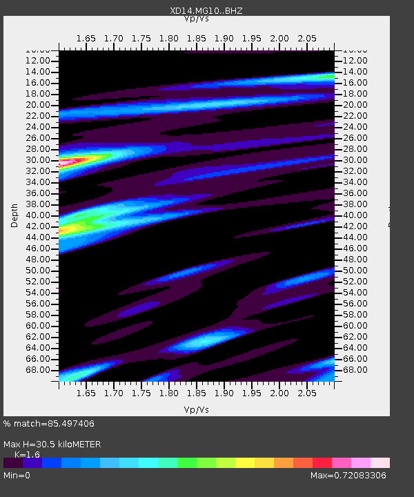
| Estimated Moho Depth: |
30.5 km |
| Estimated Crust Vp/Vs: |
1.60 |
| Assumed Crust Vp: |
6.597 km/s |
| Estimated Crust Vs: |
4.123 km/s |
| Estimated Crust Poisson's Ratio: |
0.18 |
|
| Radial Match: |
85.497406 % |
| Radial Bump: |
323 |
| Transverse Match: |
49.661816 % |
| Transverse Bump: |
400 |
| SOD ConfigId: |
7422571 |
| Insert Time: |
2019-04-19 15:51:51.552 +0000 |
| GWidth: |
2.5 |
| Max Bumps: |
400 |
| Tol: |
0.001 |
|

Signal To Noise
| Channel | StoN | STA | LTA |
| XD:MG10: :BHZ:20150706T12:35:51.975012Z | 5.3731766 | 6.476673E-7 | 1.2053714E-7 |
| XD:MG10: :BHN:20150706T12:35:51.975012Z | 3.184121 | 2.4083116E-7 | 7.563505E-8 |
| XD:MG10: :BHE:20150706T12:35:51.975012Z | 1.8798281 | 2.4501327E-7 | 1.3033812E-7 |
| Arrivals |
| Ps | 2.9 SECOND |
| PpPs | 12 SECOND |
| PsPs/PpSs | 15 SECOND |


