You are here: Home > Network List > XD14 - Illuminating the architecture of the greater Mount St. Helens magmatic systems f Stations List
> Station MH11 "Mount St Helens, WA" > Earthquake Result Viewer
MH11 "Mount St Helens, WA" - Earthquake Result Viewer
| Earthquake location: |
Tonga Islands |
| Earthquake latitude/longitude: |
-20.8/-174.5 |
| Earthquake time(UTC): |
2015/07/06 (187) 12:24:00 GMT |
| Earthquake Depth: |
1.0 km |
| Earthquake Magnitude: |
6.2 MO |
| Earthquake Catalog/Contributor: |
NEIC PDE/NEIC ALERT |
|
| Network: |
XD Illuminating the architecture of the greater Mount St. Helens magmatic systems f |
| Station: |
MH11 "Mount St Helens, WA" |
| Lat/Lon: |
46.27 N/121.58 W |
| Elevation: |
1447 m |
|
| Distance: |
82.1 deg |
| Az: |
33.955 deg |
| Baz: |
228.887 deg |
| Ray Param: |
0.04713787 |
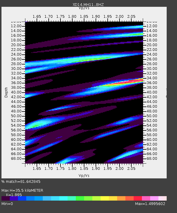
| Estimated Moho Depth: |
35.5 km |
| Estimated Crust Vp/Vs: |
2.00 |
| Assumed Crust Vp: |
6.597 km/s |
| Estimated Crust Vs: |
3.307 km/s |
| Estimated Crust Poisson's Ratio: |
0.33 |
|
| Radial Match: |
81.642845 % |
| Radial Bump: |
400 |
| Transverse Match: |
75.88222 % |
| Transverse Bump: |
400 |
| SOD ConfigId: |
7422571 |
| Insert Time: |
2019-04-19 15:51:55.804 +0000 |
| GWidth: |
2.5 |
| Max Bumps: |
400 |
| Tol: |
0.001 |
|

Signal To Noise
| Channel | StoN | STA | LTA |
| XD:MH11: :BHZ:20150706T12:35:51.939978Z | 5.425858 | 6.4090557E-7 | 1.18120596E-7 |
| XD:MH11: :BHN:20150706T12:35:51.939978Z | 1.302906 | 2.0759788E-7 | 1.593345E-7 |
| XD:MH11: :BHE:20150706T12:35:51.939978Z | 1.8228544 | 3.9606562E-7 | 2.172777E-7 |
| Arrivals |
| Ps | 5.5 SECOND |
| PpPs | 16 SECOND |
| PsPs/PpSs | 21 SECOND |


