You are here: Home > Network List > YT07 - POLENET Stations List
> Station ALYS ALYS > Earthquake Result Viewer
ALYS ALYS - Earthquake Result Viewer
| Earthquake location: |
Tonga Islands |
| Earthquake latitude/longitude: |
-20.8/-174.5 |
| Earthquake time(UTC): |
2015/07/06 (187) 12:24:00 GMT |
| Earthquake Depth: |
1.0 km |
| Earthquake Magnitude: |
6.2 MO |
| Earthquake Catalog/Contributor: |
NEIC PDE/NEIC ALERT |
|
| Network: |
YT POLENET |
| Station: |
ALYS ALYS |
| Lat/Lon: |
84.35 S/23.73 W |
| Elevation: |
2084 m |
|
| Distance: |
74.3 deg |
| Az: |
177.118 deg |
| Baz: |
208.361 deg |
| Ray Param: |
0.05242834 |
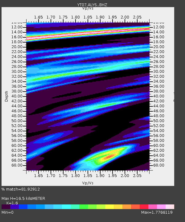
| Estimated Moho Depth: |
16.5 km |
| Estimated Crust Vp/Vs: |
1.60 |
| Assumed Crust Vp: |
6.356 km/s |
| Estimated Crust Vs: |
3.973 km/s |
| Estimated Crust Poisson's Ratio: |
0.18 |
|
| Radial Match: |
81.92912 % |
| Radial Bump: |
400 |
| Transverse Match: |
61.91759 % |
| Transverse Bump: |
400 |
| SOD ConfigId: |
7422571 |
| Insert Time: |
2019-04-19 15:52:38.494 +0000 |
| GWidth: |
2.5 |
| Max Bumps: |
400 |
| Tol: |
0.001 |
|

Signal To Noise
| Channel | StoN | STA | LTA |
| YT:ALYS: :BHZ:20150706T12:35:08.824988Z | 3.046474 | 5.264395E-7 | 1.7280288E-7 |
| YT:ALYS: :BHN:20150706T12:35:08.824988Z | 1.7175505 | 3.1295505E-7 | 1.822101E-7 |
| YT:ALYS: :BHE:20150706T12:35:08.824988Z | 1.2192569 | 2.9043926E-7 | 2.3821005E-7 |
| Arrivals |
| Ps | 1.6 SECOND |
| PpPs | 6.5 SECOND |
| PsPs/PpSs | 8.1 SECOND |


