You are here: Home > Network List > GS - US Geological Survey Networks Stations List
> Station KAN10 Keim Farm, Anthony, KS, USA > Earthquake Result Viewer
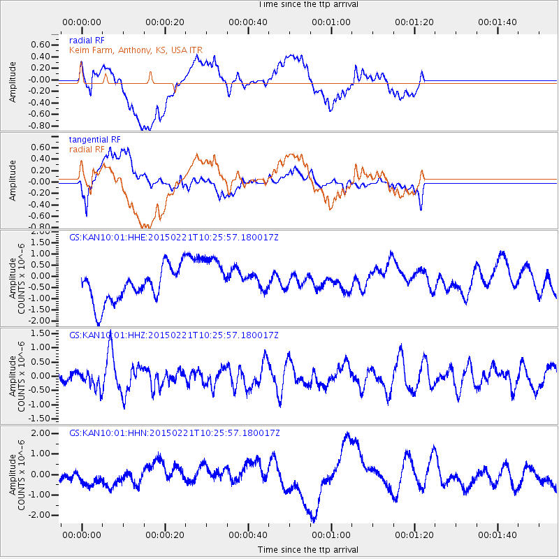
KAN10 Keim Farm, Anthony, KS, USA - Earthquake Result Viewer
*The percent match for this event was below the threshold and hence no stack was calculated.
| Earthquake location: |
Off East Coast Of Honshu, Japan |
| Earthquake latitude/longitude: |
39.9/143.4 |
| Earthquake time(UTC): |
2015/02/21 (052) 10:13:54 GMT |
| Earthquake Depth: |
10 km |
| Earthquake Magnitude: |
6.1 MO |
| Earthquake Catalog/Contributor: |
NEIC PDE/NEIC ALERT |
|
| Network: |
GS US Geological Survey Networks |
| Station: |
KAN10 Keim Farm, Anthony, KS, USA |
| Lat/Lon: |
37.12 N/98.10 W |
| Elevation: |
417 m |
|
| Distance: |
84.8 deg |
| Az: |
44.865 deg |
| Baz: |
317.209 deg |
| Ray Param: |
$rayparam |
*The percent match for this event was below the threshold and hence was not used in the summary stack. |
|
| Radial Match: |
39.143112 % |
| Radial Bump: |
400 |
| Transverse Match: |
44.169407 % |
| Transverse Bump: |
400 |
| SOD ConfigId: |
872571 |
| Insert Time: |
2015-03-07 10:26:02.762 +0000 |
| GWidth: |
2.5 |
| Max Bumps: |
400 |
| Tol: |
0.001 |
|
Signal To Noise
| Channel | StoN | STA | LTA |
| GS:KAN10:01:HHZ:20150221T10:25:57.180017Z | 0.87656873 | 2.890414E-7 | 3.2974185E-7 |
| GS:KAN10:01:HHN:20150221T10:25:57.180017Z | 0.78263533 | 5.274086E-7 | 6.7388805E-7 |
| GS:KAN10:01:HHE:20150221T10:25:57.180017Z | 1.5051968 | 1.1218225E-6 | 7.452996E-7 |
| Arrivals |
| Ps | |
| PpPs | |
| PsPs/PpSs | |


