You are here: Home > Network List > CI - Caltech Regional Seismic Network Stations List
> Station SWS Sam W. Stewart, Westmorland, CA, USA > Earthquake Result Viewer
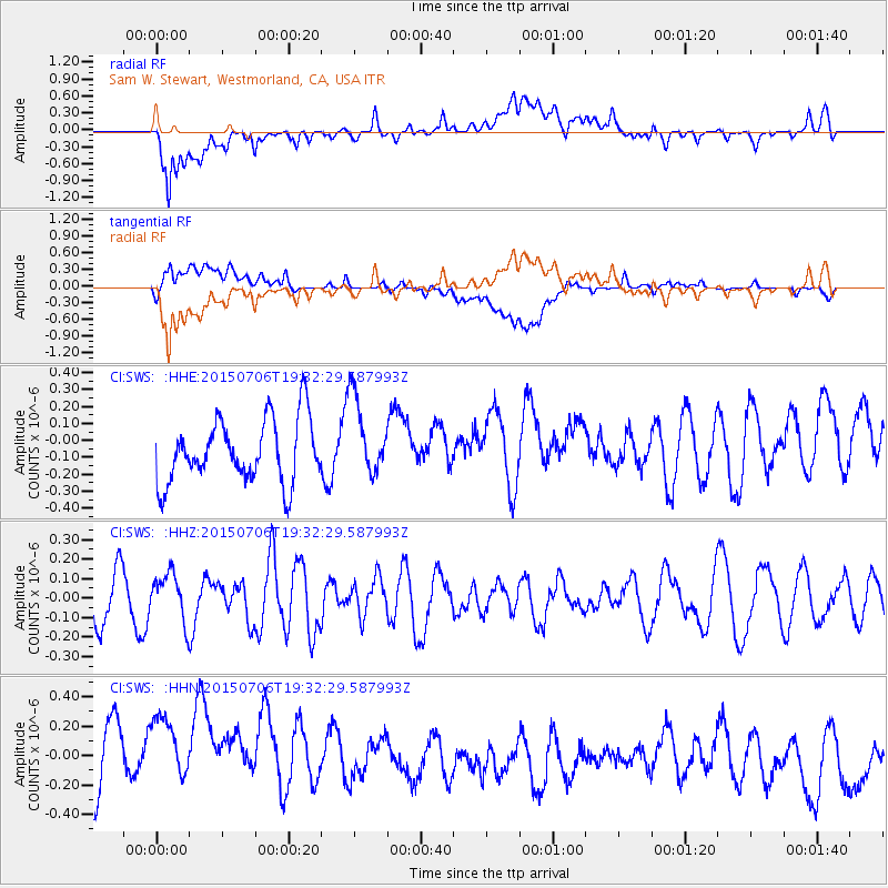
SWS Sam W. Stewart, Westmorland, CA, USA - Earthquake Result Viewer
*The percent match for this event was below the threshold and hence no stack was calculated.
| Earthquake location: |
Tonga Islands |
| Earthquake latitude/longitude: |
-21.3/-174.3 |
| Earthquake time(UTC): |
2015/07/06 (187) 19:21:05 GMT |
| Earthquake Depth: |
13 km |
| Earthquake Magnitude: |
5.3 MW |
| Earthquake Catalog/Contributor: |
ISC/ISC |
|
| Network: |
CI Caltech Regional Seismic Network |
| Station: |
SWS Sam W. Stewart, Westmorland, CA, USA |
| Lat/Lon: |
32.94 N/115.80 W |
| Elevation: |
140 m |
|
| Distance: |
77.6 deg |
| Az: |
47.233 deg |
| Baz: |
234.522 deg |
| Ray Param: |
$rayparam |
*The percent match for this event was below the threshold and hence was not used in the summary stack. |
|
| Radial Match: |
50.278492 % |
| Radial Bump: |
400 |
| Transverse Match: |
31.777262 % |
| Transverse Bump: |
400 |
| SOD ConfigId: |
7422571 |
| Insert Time: |
2019-04-19 16:02:00.711 +0000 |
| GWidth: |
2.5 |
| Max Bumps: |
400 |
| Tol: |
0.001 |
|
Signal To Noise
| Channel | StoN | STA | LTA |
| CI:SWS: :HHZ:20150706T19:32:29.587993Z | 1.1246021 | 1.2100479E-7 | 1.0759786E-7 |
| CI:SWS: :HHN:20150706T19:32:29.587993Z | 1.0338408 | 4.752396E-7 | 4.5968355E-7 |
| CI:SWS: :HHE:20150706T19:32:29.587993Z | 1.2618364 | 2.3374632E-7 | 1.8524297E-7 |
| Arrivals |
| Ps | |
| PpPs | |
| PsPs/PpSs | |


