You are here: Home > Network List > GS - US Geological Survey Networks Stations List
> Station OK031 2598 S. Brethren Rd., Cushing, OK, USA > Earthquake Result Viewer
OK031 2598 S. Brethren Rd., Cushing, OK, USA - Earthquake Result Viewer
| Earthquake location: |
Tonga Islands |
| Earthquake latitude/longitude: |
-21.3/-174.3 |
| Earthquake time(UTC): |
2015/07/06 (187) 19:21:05 GMT |
| Earthquake Depth: |
13 km |
| Earthquake Magnitude: |
5.3 MW |
| Earthquake Catalog/Contributor: |
ISC/ISC |
|
| Network: |
GS US Geological Survey Networks |
| Station: |
OK031 2598 S. Brethren Rd., Cushing, OK, USA |
| Lat/Lon: |
35.95 N/96.84 W |
| Elevation: |
290 m |
|
| Distance: |
92.7 deg |
| Az: |
52.454 deg |
| Baz: |
245.714 deg |
| Ray Param: |
0.041413356 |
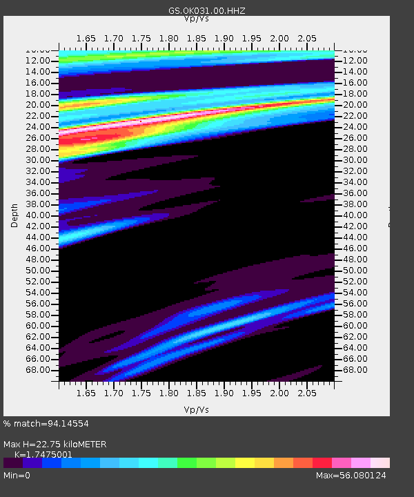
| Estimated Moho Depth: |
22.75 km |
| Estimated Crust Vp/Vs: |
1.75 |
| Assumed Crust Vp: |
6.426 km/s |
| Estimated Crust Vs: |
3.677 km/s |
| Estimated Crust Poisson's Ratio: |
0.26 |
|
| Radial Match: |
94.14554 % |
| Radial Bump: |
309 |
| Transverse Match: |
57.50262 % |
| Transverse Bump: |
340 |
| SOD ConfigId: |
7422571 |
| Insert Time: |
2019-04-19 16:02:46.277 +0000 |
| GWidth: |
2.5 |
| Max Bumps: |
400 |
| Tol: |
0.001 |
|

Signal To Noise
| Channel | StoN | STA | LTA |
| GS:OK031:00:HHZ:20150706T19:33:44.993999Z | 1.5719308 | 2.4097943E-7 | 1.5330157E-7 |
| GS:OK031:00:HH1:20150706T19:33:44.993999Z | 1.0680268 | 5.9895424E-6 | 5.6080453E-6 |
| GS:OK031:00:HH2:20150706T19:33:44.993999Z | 1.6470711 | 1.6478185E-5 | 1.0004538E-5 |
| Arrivals |
| Ps | 2.7 SECOND |
| PpPs | 9.5 SECOND |
| PsPs/PpSs | 12 SECOND |


