You are here: Home > Network List > TA - USArray Transportable Network (new EarthScope stations) Stations List
> Station R11A Troy Canyon, Currant, NV, USA > Earthquake Result Viewer
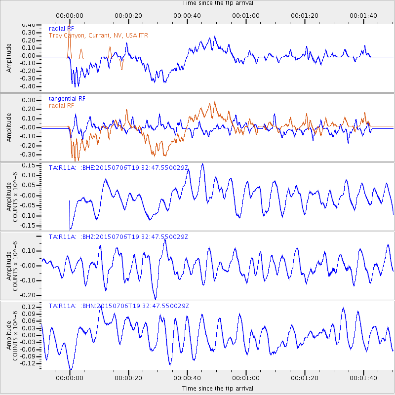
R11A Troy Canyon, Currant, NV, USA - Earthquake Result Viewer
*The percent match for this event was below the threshold and hence no stack was calculated.
| Earthquake location: |
Tonga Islands |
| Earthquake latitude/longitude: |
-21.3/-174.3 |
| Earthquake time(UTC): |
2015/07/06 (187) 19:21:05 GMT |
| Earthquake Depth: |
13 km |
| Earthquake Magnitude: |
5.3 MW |
| Earthquake Catalog/Contributor: |
ISC/ISC |
|
| Network: |
TA USArray Transportable Network (new EarthScope stations) |
| Station: |
R11A Troy Canyon, Currant, NV, USA |
| Lat/Lon: |
38.35 N/115.59 W |
| Elevation: |
1756 m |
|
| Distance: |
80.9 deg |
| Az: |
42.882 deg |
| Baz: |
233.832 deg |
| Ray Param: |
$rayparam |
*The percent match for this event was below the threshold and hence was not used in the summary stack. |
|
| Radial Match: |
35.978016 % |
| Radial Bump: |
400 |
| Transverse Match: |
43.18496 % |
| Transverse Bump: |
400 |
| SOD ConfigId: |
7422571 |
| Insert Time: |
2019-04-19 16:04:51.032 +0000 |
| GWidth: |
2.5 |
| Max Bumps: |
400 |
| Tol: |
0.001 |
|
Signal To Noise
| Channel | StoN | STA | LTA |
| TA:R11A: :BHZ:20150706T19:32:47.550029Z | 0.5486285 | 3.9350404E-8 | 7.172505E-8 |
| TA:R11A: :BHN:20150706T19:32:47.550029Z | 0.9887878 | 7.0059976E-8 | 7.085441E-8 |
| TA:R11A: :BHE:20150706T19:32:47.550029Z | 0.72189575 | 3.7102104E-8 | 5.1395375E-8 |
| Arrivals |
| Ps | |
| PpPs | |
| PsPs/PpSs | |


