You are here: Home > Network List > US - United States National Seismic Network Stations List
> Station CBKS Cedar Bluff, Kansas, USA > Earthquake Result Viewer
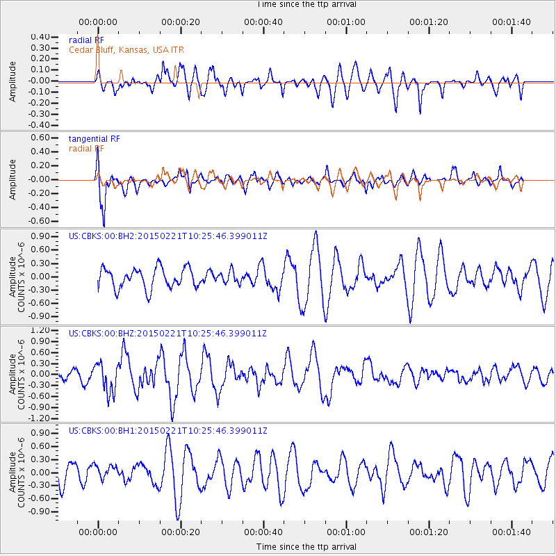
CBKS Cedar Bluff, Kansas, USA - Earthquake Result Viewer
*The percent match for this event was below the threshold and hence no stack was calculated.
| Earthquake location: |
Off East Coast Of Honshu, Japan |
| Earthquake latitude/longitude: |
39.9/143.4 |
| Earthquake time(UTC): |
2015/02/21 (052) 10:13:54 GMT |
| Earthquake Depth: |
10 km |
| Earthquake Magnitude: |
6.1 MO |
| Earthquake Catalog/Contributor: |
NEIC PDE/NEIC ALERT |
|
| Network: |
US United States National Seismic Network |
| Station: |
CBKS Cedar Bluff, Kansas, USA |
| Lat/Lon: |
38.81 N/99.74 W |
| Elevation: |
677 m |
|
| Distance: |
82.7 deg |
| Az: |
44.651 deg |
| Baz: |
316.18 deg |
| Ray Param: |
$rayparam |
*The percent match for this event was below the threshold and hence was not used in the summary stack. |
|
| Radial Match: |
56.765438 % |
| Radial Bump: |
400 |
| Transverse Match: |
72.57031 % |
| Transverse Bump: |
400 |
| SOD ConfigId: |
872571 |
| Insert Time: |
2015-03-07 10:30:50.193 +0000 |
| GWidth: |
2.5 |
| Max Bumps: |
400 |
| Tol: |
0.001 |
|
Signal To Noise
| Channel | StoN | STA | LTA |
| US:CBKS:00:BHZ:20150221T10:25:46.399011Z | 1.7850704 | 4.0983696E-7 | 2.2959148E-7 |
| US:CBKS:00:BH1:20150221T10:25:46.399011Z | 0.39139414 | 1.531182E-7 | 3.912123E-7 |
| US:CBKS:00:BH2:20150221T10:25:46.399011Z | 0.6059161 | 1.3614925E-7 | 2.2469986E-7 |
| Arrivals |
| Ps | |
| PpPs | |
| PsPs/PpSs | |


