You are here: Home > Network List > 7A - Mid-Atlantic Geophysical Integrative Collaboration Stations List
> Station CDRF Friendly, West Virginia USA > Earthquake Result Viewer
CDRF Friendly, West Virginia USA - Earthquake Result Viewer
| Earthquake location: |
Kuril Islands |
| Earthquake latitude/longitude: |
44.0/147.9 |
| Earthquake time(UTC): |
2015/07/07 (188) 05:10:27 GMT |
| Earthquake Depth: |
38 km |
| Earthquake Magnitude: |
6.3 MO |
| Earthquake Catalog/Contributor: |
NEIC PDE/NEIC ALERT |
|
| Network: |
7A Mid-Atlantic Geophysical Integrative Collaboration |
| Station: |
CDRF Friendly, West Virginia USA |
| Lat/Lon: |
39.46 N/81.05 W |
| Elevation: |
282 m |
|
| Distance: |
85.9 deg |
| Az: |
35.852 deg |
| Baz: |
326.902 deg |
| Ray Param: |
0.044372074 |
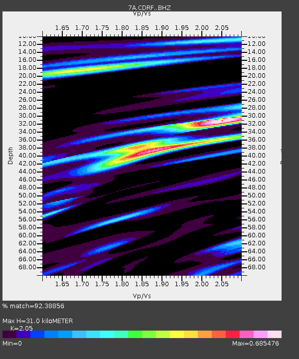
| Estimated Moho Depth: |
31.0 km |
| Estimated Crust Vp/Vs: |
2.05 |
| Assumed Crust Vp: |
6.207 km/s |
| Estimated Crust Vs: |
3.028 km/s |
| Estimated Crust Poisson's Ratio: |
0.34 |
|
| Radial Match: |
92.38856 % |
| Radial Bump: |
400 |
| Transverse Match: |
88.65402 % |
| Transverse Bump: |
400 |
| SOD ConfigId: |
7422571 |
| Insert Time: |
2019-04-19 16:07:15.192 +0000 |
| GWidth: |
2.5 |
| Max Bumps: |
400 |
| Tol: |
0.001 |
|

Signal To Noise
| Channel | StoN | STA | LTA |
| 7A:CDRF: :BHZ:20150707T05:22:31.090015Z | 43.70407 | 4.1372127E-6 | 9.4664244E-8 |
| 7A:CDRF: :BHN:20150707T05:22:31.090015Z | 10.034554 | 1.0943673E-6 | 1.09059904E-7 |
| 7A:CDRF: :BHE:20150707T05:22:31.090015Z | 5.9868417 | 6.474521E-7 | 1.08145855E-7 |
| Arrivals |
| Ps | 5.3 SECOND |
| PpPs | 15 SECOND |
| PsPs/PpSs | 20 SECOND |


