You are here: Home > Network List > 7A - Mid-Atlantic Geophysical Integrative Collaboration Stations List
> Station ALMA Alma, West Virginia USA > Earthquake Result Viewer
ALMA Alma, West Virginia USA - Earthquake Result Viewer
| Earthquake location: |
Kuril Islands |
| Earthquake latitude/longitude: |
44.0/147.9 |
| Earthquake time(UTC): |
2015/07/07 (188) 05:10:27 GMT |
| Earthquake Depth: |
38 km |
| Earthquake Magnitude: |
6.3 MO |
| Earthquake Catalog/Contributor: |
NEIC PDE/NEIC ALERT |
|
| Network: |
7A Mid-Atlantic Geophysical Integrative Collaboration |
| Station: |
ALMA Alma, West Virginia USA |
| Lat/Lon: |
39.40 N/80.84 W |
| Elevation: |
233 m |
|
| Distance: |
86.0 deg |
| Az: |
35.739 deg |
| Baz: |
327.031 deg |
| Ray Param: |
0.04427739 |
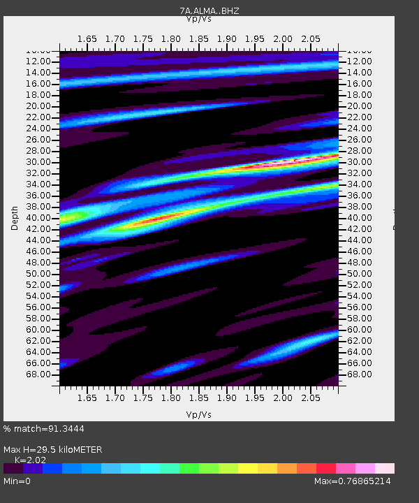
| Estimated Moho Depth: |
29.5 km |
| Estimated Crust Vp/Vs: |
2.02 |
| Assumed Crust Vp: |
6.207 km/s |
| Estimated Crust Vs: |
3.073 km/s |
| Estimated Crust Poisson's Ratio: |
0.34 |
|
| Radial Match: |
91.3444 % |
| Radial Bump: |
400 |
| Transverse Match: |
81.21594 % |
| Transverse Bump: |
400 |
| SOD ConfigId: |
7422571 |
| Insert Time: |
2019-04-19 16:07:12.245 +0000 |
| GWidth: |
2.5 |
| Max Bumps: |
400 |
| Tol: |
0.001 |
|

Signal To Noise
| Channel | StoN | STA | LTA |
| 7A:ALMA: :BHZ:20150707T05:22:31.739978Z | 41.13202 | 4.352153E-6 | 1.0580938E-7 |
| 7A:ALMA: :BHN:20150707T05:22:31.739978Z | 11.338406 | 1.1802301E-6 | 1.04091356E-7 |
| 7A:ALMA: :BHE:20150707T05:22:31.739978Z | 10.250028 | 8.1215677E-7 | 7.9234596E-8 |
| Arrivals |
| Ps | 4.9 SECOND |
| PpPs | 14 SECOND |
| PsPs/PpSs | 19 SECOND |


