You are here: Home > Network List > 7A - Mid-Atlantic Geophysical Integrative Collaboration Stations List
> Station MOLE Hinton, Virginia USA > Earthquake Result Viewer
MOLE Hinton, Virginia USA - Earthquake Result Viewer
| Earthquake location: |
Kuril Islands |
| Earthquake latitude/longitude: |
44.0/147.9 |
| Earthquake time(UTC): |
2015/07/07 (188) 05:10:27 GMT |
| Earthquake Depth: |
38 km |
| Earthquake Magnitude: |
6.3 MO |
| Earthquake Catalog/Contributor: |
NEIC PDE/NEIC ALERT |
|
| Network: |
7A Mid-Atlantic Geophysical Integrative Collaboration |
| Station: |
MOLE Hinton, Virginia USA |
| Lat/Lon: |
38.49 N/79.02 W |
| Elevation: |
487 m |
|
| Distance: |
87.6 deg |
| Az: |
35.029 deg |
| Baz: |
328.13 deg |
| Ray Param: |
0.043173313 |
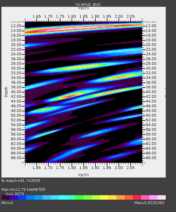
| Estimated Moho Depth: |
12.75 km |
| Estimated Crust Vp/Vs: |
1.81 |
| Assumed Crust Vp: |
6.159 km/s |
| Estimated Crust Vs: |
3.407 km/s |
| Estimated Crust Poisson's Ratio: |
0.28 |
|
| Radial Match: |
91.742935 % |
| Radial Bump: |
400 |
| Transverse Match: |
82.01488 % |
| Transverse Bump: |
400 |
| SOD ConfigId: |
7422571 |
| Insert Time: |
2019-04-19 16:07:23.532 +0000 |
| GWidth: |
2.5 |
| Max Bumps: |
400 |
| Tol: |
0.001 |
|

Signal To Noise
| Channel | StoN | STA | LTA |
| 7A:MOLE: :BHZ:20150707T05:22:39.160022Z | 25.981417 | 3.0302604E-6 | 1.1663183E-7 |
| 7A:MOLE: :BHN:20150707T05:22:39.160022Z | 9.795435 | 8.886602E-7 | 9.0721876E-8 |
| 7A:MOLE: :BHE:20150707T05:22:39.160022Z | 5.0102644 | 4.168436E-7 | 8.319792E-8 |
| Arrivals |
| Ps | 1.7 SECOND |
| PpPs | 5.7 SECOND |
| PsPs/PpSs | 7.4 SECOND |


