You are here: Home > Network List > 7A - Mid-Atlantic Geophysical Integrative Collaboration Stations List
> Station RTSN Coon Bone Island, West Virginia USA > Earthquake Result Viewer
RTSN Coon Bone Island, West Virginia USA - Earthquake Result Viewer
| Earthquake location: |
Kuril Islands |
| Earthquake latitude/longitude: |
44.0/147.9 |
| Earthquake time(UTC): |
2015/07/07 (188) 05:10:27 GMT |
| Earthquake Depth: |
38 km |
| Earthquake Magnitude: |
6.3 MO |
| Earthquake Catalog/Contributor: |
NEIC PDE/NEIC ALERT |
|
| Network: |
7A Mid-Atlantic Geophysical Integrative Collaboration |
| Station: |
RTSN Coon Bone Island, West Virginia USA |
| Lat/Lon: |
38.94 N/79.58 W |
| Elevation: |
949 m |
|
| Distance: |
87.0 deg |
| Az: |
35.164 deg |
| Baz: |
327.785 deg |
| Ray Param: |
0.04361764 |
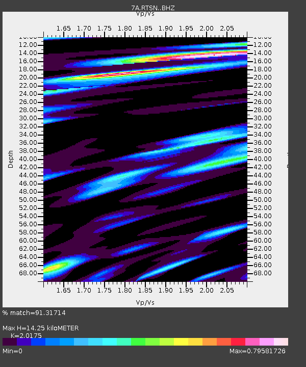
| Estimated Moho Depth: |
14.25 km |
| Estimated Crust Vp/Vs: |
2.02 |
| Assumed Crust Vp: |
6.159 km/s |
| Estimated Crust Vs: |
3.053 km/s |
| Estimated Crust Poisson's Ratio: |
0.34 |
|
| Radial Match: |
91.31714 % |
| Radial Bump: |
400 |
| Transverse Match: |
92.240555 % |
| Transverse Bump: |
400 |
| SOD ConfigId: |
7422571 |
| Insert Time: |
2019-04-19 16:07:28.036 +0000 |
| GWidth: |
2.5 |
| Max Bumps: |
400 |
| Tol: |
0.001 |
|

Signal To Noise
| Channel | StoN | STA | LTA |
| 7A:RTSN: :BHZ:20150707T05:22:36.18999Z | 20.54599 | 3.6713095E-6 | 1.7868739E-7 |
| 7A:RTSN: :BHN:20150707T05:22:36.18999Z | 6.198092 | 7.267251E-7 | 1.1724981E-7 |
| 7A:RTSN: :BHE:20150707T05:22:36.18999Z | 6.3216114 | 6.3963085E-7 | 1.0118162E-7 |
| Arrivals |
| Ps | 2.4 SECOND |
| PpPs | 6.9 SECOND |
| PsPs/PpSs | 9.3 SECOND |


