You are here: Home > Network List > 7A - Mid-Atlantic Geophysical Integrative Collaboration Stations List
> Station WINE Liberty, Virginia USA > Earthquake Result Viewer
WINE Liberty, Virginia USA - Earthquake Result Viewer
| Earthquake location: |
Kuril Islands |
| Earthquake latitude/longitude: |
44.0/147.9 |
| Earthquake time(UTC): |
2015/07/07 (188) 05:10:27 GMT |
| Earthquake Depth: |
38 km |
| Earthquake Magnitude: |
6.3 MO |
| Earthquake Catalog/Contributor: |
NEIC PDE/NEIC ALERT |
|
| Network: |
7A Mid-Atlantic Geophysical Integrative Collaboration |
| Station: |
WINE Liberty, Virginia USA |
| Lat/Lon: |
38.16 N/78.32 W |
| Elevation: |
119 m |
|
| Distance: |
88.1 deg |
| Az: |
34.736 deg |
| Baz: |
328.55 deg |
| Ray Param: |
0.042749986 |
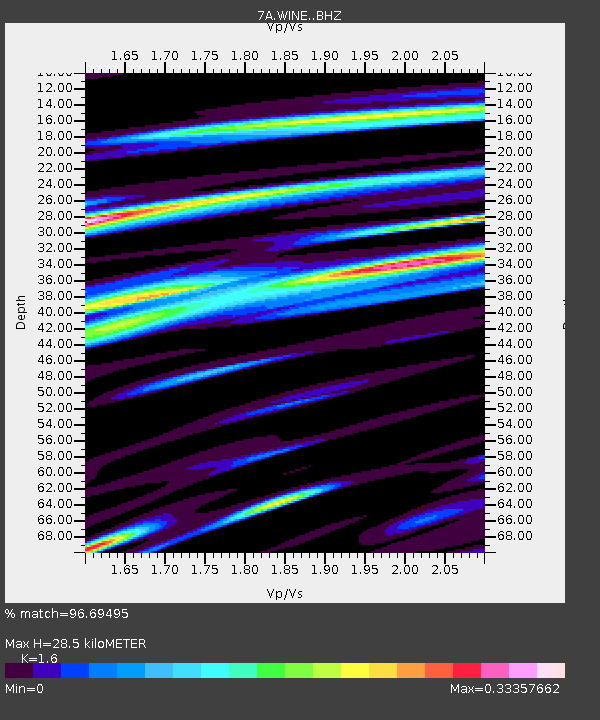
| Estimated Moho Depth: |
28.5 km |
| Estimated Crust Vp/Vs: |
1.60 |
| Assumed Crust Vp: |
6.159 km/s |
| Estimated Crust Vs: |
3.849 km/s |
| Estimated Crust Poisson's Ratio: |
0.18 |
|
| Radial Match: |
96.69495 % |
| Radial Bump: |
299 |
| Transverse Match: |
91.68117 % |
| Transverse Bump: |
400 |
| SOD ConfigId: |
7422571 |
| Insert Time: |
2019-04-19 16:07:28.091 +0000 |
| GWidth: |
2.5 |
| Max Bumps: |
400 |
| Tol: |
0.001 |
|

Signal To Noise
| Channel | StoN | STA | LTA |
| 7A:WINE: :BHZ:20150707T05:22:41.890002Z | 41.534466 | 3.6585889E-6 | 8.808561E-8 |
| 7A:WINE: :BHN:20150707T05:22:41.890002Z | 21.07109 | 1.1074953E-6 | 5.2559944E-8 |
| 7A:WINE: :BHE:20150707T05:22:41.890002Z | 7.558 | 5.2186766E-7 | 6.904838E-8 |
| Arrivals |
| Ps | 2.8 SECOND |
| PpPs | 12 SECOND |
| PsPs/PpSs | 15 SECOND |


