You are here: Home > Network List > AK - Alaska Regional Network Stations List
> Station CUT Chulitna, AK, USA > Earthquake Result Viewer
CUT Chulitna, AK, USA - Earthquake Result Viewer

| Earthquake location: |
Kuril Islands |
| Earthquake latitude/longitude: |
44.0/147.9 |
| Earthquake time(UTC): |
2015/07/07 (188) 05:10:27 GMT |
| Earthquake Depth: |
38 km |
| Earthquake Magnitude: |
6.3 MO |
| Earthquake Catalog/Contributor: |
NEIC PDE/NEIC ALERT |
|
| Network: |
AK Alaska Regional Network |
| Station: |
CUT Chulitna, AK, USA |
| Lat/Lon: |
62.41 N/150.26 W |
| Elevation: |
574 m |
|
| Distance: |
39.5 deg |
| Az: |
40.148 deg |
| Baz: |
271.837 deg |
| Ray Param: |
0.074849494 |
| Estimated Moho Depth: |
22.0 km |
| Estimated Crust Vp/Vs: |
1.88 |
| Assumed Crust Vp: |
6.438 km/s |
| Estimated Crust Vs: |
3.434 km/s |
| Estimated Crust Poisson's Ratio: |
0.30 |
|
| Radial Match: |
81.81168 % |
| Radial Bump: |
273 |
| Transverse Match: |
71.79857 % |
| Transverse Bump: |
400 |
| SOD ConfigId: |
7422571 |
| Insert Time: |
2019-04-19 16:08:03.792 +0000 |
| GWidth: |
2.5 |
| Max Bumps: |
400 |
| Tol: |
0.001 |
|
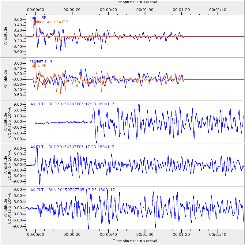
Signal To Noise
| Channel | StoN | STA | LTA |
| AK:CUT: :BHZ:20150707T05:17:23.180011Z | 42.5834 | 5.4413936E-6 | 1.2778203E-7 |
| AK:CUT: :BHN:20150707T05:17:23.180011Z | 7.284788 | 1.575392E-6 | 2.1625777E-7 |
| AK:CUT: :BHE:20150707T05:17:23.180011Z | 17.02908 | 5.250716E-6 | 3.083382E-7 |
| Arrivals |
| Ps | 3.2 SECOND |
| PpPs | 9.2 SECOND |
| PsPs/PpSs | 12 SECOND |


