You are here: Home > Network List > AK - Alaska Regional Network Stations List
> Station ISLE Juniper Island, AK, USA > Earthquake Result Viewer
ISLE Juniper Island, AK, USA - Earthquake Result Viewer
| Earthquake location: |
Kuril Islands |
| Earthquake latitude/longitude: |
44.0/147.9 |
| Earthquake time(UTC): |
2015/07/07 (188) 05:10:27 GMT |
| Earthquake Depth: |
38 km |
| Earthquake Magnitude: |
6.3 MO |
| Earthquake Catalog/Contributor: |
NEIC PDE/NEIC ALERT |
|
| Network: |
AK Alaska Regional Network |
| Station: |
ISLE Juniper Island, AK, USA |
| Lat/Lon: |
60.60 N/142.34 W |
| Elevation: |
1485 m |
|
| Distance: |
43.5 deg |
| Az: |
42.249 deg |
| Baz: |
280.366 deg |
| Ray Param: |
0.07242596 |
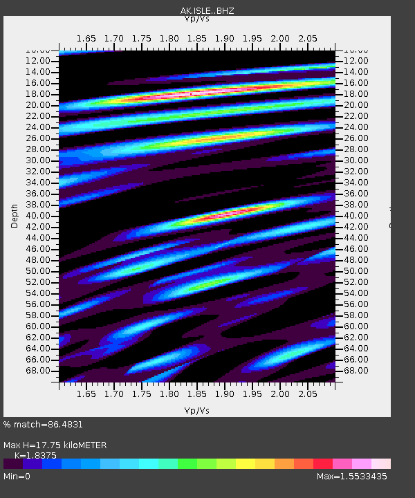
| Estimated Moho Depth: |
17.75 km |
| Estimated Crust Vp/Vs: |
1.84 |
| Assumed Crust Vp: |
6.566 km/s |
| Estimated Crust Vs: |
3.573 km/s |
| Estimated Crust Poisson's Ratio: |
0.29 |
|
| Radial Match: |
86.4831 % |
| Radial Bump: |
400 |
| Transverse Match: |
77.89274 % |
| Transverse Bump: |
400 |
| SOD ConfigId: |
7422571 |
| Insert Time: |
2019-04-19 16:08:18.593 +0000 |
| GWidth: |
2.5 |
| Max Bumps: |
400 |
| Tol: |
0.001 |
|

Signal To Noise
| Channel | StoN | STA | LTA |
| AK:ISLE: :BHZ:20150707T05:17:55.60799Z | 59.685383 | 5.747417E-6 | 9.6295224E-8 |
| AK:ISLE: :BHN:20150707T05:17:55.60799Z | 12.046468 | 2.0343373E-6 | 1.6887417E-7 |
| AK:ISLE: :BHE:20150707T05:17:55.60799Z | 71.768135 | 4.2325314E-6 | 5.897508E-8 |
| Arrivals |
| Ps | 2.4 SECOND |
| PpPs | 7.2 SECOND |
| PsPs/PpSs | 9.6 SECOND |


