You are here: Home > Network List > AZ - ANZA Regional Network Stations List
> Station BZN AZ.BZN > Earthquake Result Viewer
BZN AZ.BZN - Earthquake Result Viewer
| Earthquake location: |
Kuril Islands |
| Earthquake latitude/longitude: |
44.0/147.9 |
| Earthquake time(UTC): |
2015/07/07 (188) 05:10:27 GMT |
| Earthquake Depth: |
38 km |
| Earthquake Magnitude: |
6.3 MO |
| Earthquake Catalog/Contributor: |
NEIC PDE/NEIC ALERT |
|
| Network: |
AZ ANZA Regional Network |
| Station: |
BZN AZ.BZN |
| Lat/Lon: |
33.49 N/116.67 W |
| Elevation: |
1301 m |
|
| Distance: |
71.1 deg |
| Az: |
61.546 deg |
| Baz: |
310.585 deg |
| Ray Param: |
0.054464463 |
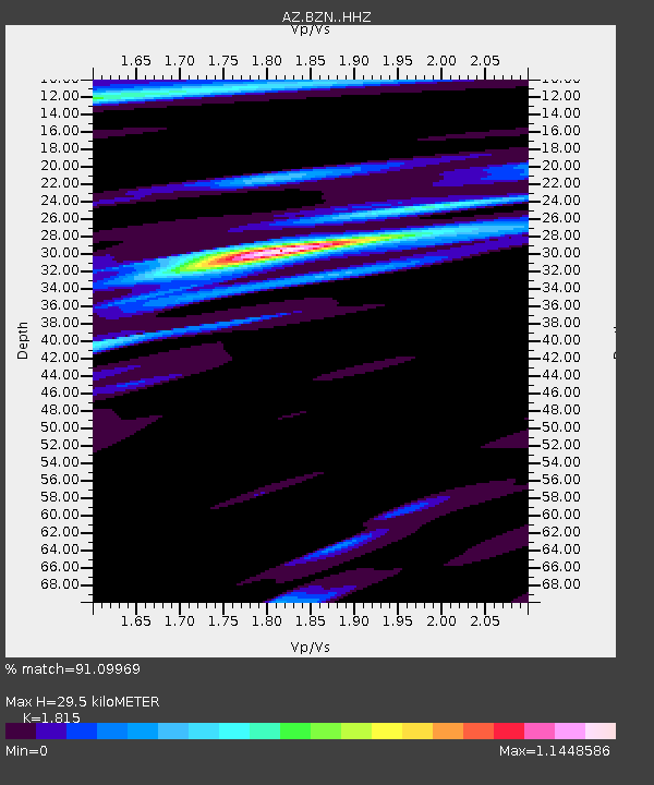
| Estimated Moho Depth: |
29.5 km |
| Estimated Crust Vp/Vs: |
1.82 |
| Assumed Crust Vp: |
6.264 km/s |
| Estimated Crust Vs: |
3.451 km/s |
| Estimated Crust Poisson's Ratio: |
0.28 |
|
| Radial Match: |
91.09969 % |
| Radial Bump: |
400 |
| Transverse Match: |
87.992546 % |
| Transverse Bump: |
395 |
| SOD ConfigId: |
7422571 |
| Insert Time: |
2019-04-19 16:09:32.498 +0000 |
| GWidth: |
2.5 |
| Max Bumps: |
400 |
| Tol: |
0.001 |
|

Signal To Noise
| Channel | StoN | STA | LTA |
| AZ:BZN: :HHZ:20150707T05:21:09.918018Z | 18.27726 | 1.8055368E-6 | 9.878597E-8 |
| AZ:BZN: :HHN:20150707T05:21:09.918018Z | 9.982415 | 7.5987464E-7 | 7.6121324E-8 |
| AZ:BZN: :HHE:20150707T05:21:09.918018Z | 2.8042595 | 4.2156984E-7 | 1.5033196E-7 |
| Arrivals |
| Ps | 4.0 SECOND |
| PpPs | 13 SECOND |
| PsPs/PpSs | 17 SECOND |


