You are here: Home > Network List > IU - Global Seismograph Network (GSN - IRIS/USGS) Stations List
> Station ULN Ulaanbaatar, Mongolia > Earthquake Result Viewer
ULN Ulaanbaatar, Mongolia - Earthquake Result Viewer
| Earthquake location: |
Vanuatu Islands |
| Earthquake latitude/longitude: |
-14.4/167.7 |
| Earthquake time(UTC): |
2002/04/11 (101) 21:56:56 GMT |
| Earthquake Depth: |
10 km |
| Earthquake Magnitude: |
5.9 MB, 6.2 MS, 6.2 MW, 6.1 MW |
| Earthquake Catalog/Contributor: |
WHDF/NEIC |
|
| Network: |
IU Global Seismograph Network (GSN - IRIS/USGS) |
| Station: |
ULN Ulaanbaatar, Mongolia |
| Lat/Lon: |
47.87 N/107.05 E |
| Elevation: |
1610 m |
|
| Distance: |
82.1 deg |
| Az: |
323.669 deg |
| Baz: |
121.506 deg |
| Ray Param: |
0.04711849 |
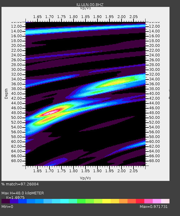
| Estimated Moho Depth: |
48.0 km |
| Estimated Crust Vp/Vs: |
1.70 |
| Assumed Crust Vp: |
6.642 km/s |
| Estimated Crust Vs: |
3.913 km/s |
| Estimated Crust Poisson's Ratio: |
0.23 |
|
| Radial Match: |
97.26884 % |
| Radial Bump: |
235 |
| Transverse Match: |
88.64972 % |
| Transverse Bump: |
396 |
| SOD ConfigId: |
20082 |
| Insert Time: |
2010-03-03 15:51:22.463 +0000 |
| GWidth: |
2.5 |
| Max Bumps: |
400 |
| Tol: |
0.001 |
|
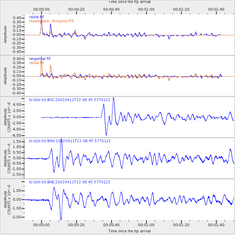
Signal To Noise
| Channel | StoN | STA | LTA |
| IU:ULN:00:BHN:20020411T22:08:45.577012Z | 2.4497662 | 9.282462E-8 | 3.7891215E-8 |
| IU:ULN:00:BHE:20020411T22:08:45.577012Z | 5.1964126 | 1.2049433E-7 | 2.3187983E-8 |
| IU:ULN:00:BHZ:20020411T22:08:45.577012Z | 8.23271 | 4.772225E-7 | 5.7966634E-8 |
| Arrivals |
| Ps | 5.2 SECOND |
| PpPs | 19 SECOND |
| PsPs/PpSs | 24 SECOND |


