You are here: Home > Network List > CC - Cascade Chain Volcano Monitoring Stations List
> Station JRO Johnston Ridge Observatory > Earthquake Result Viewer
JRO Johnston Ridge Observatory - Earthquake Result Viewer
| Earthquake location: |
Kuril Islands |
| Earthquake latitude/longitude: |
44.0/147.9 |
| Earthquake time(UTC): |
2015/07/07 (188) 05:10:27 GMT |
| Earthquake Depth: |
38 km |
| Earthquake Magnitude: |
6.3 MO |
| Earthquake Catalog/Contributor: |
NEIC PDE/NEIC ALERT |
|
| Network: |
CC Cascade Chain Volcano Monitoring |
| Station: |
JRO Johnston Ridge Observatory |
| Lat/Lon: |
46.28 N/122.22 W |
| Elevation: |
1280 m |
|
| Distance: |
60.0 deg |
| Az: |
53.211 deg |
| Baz: |
303.547 deg |
| Ray Param: |
0.061742418 |
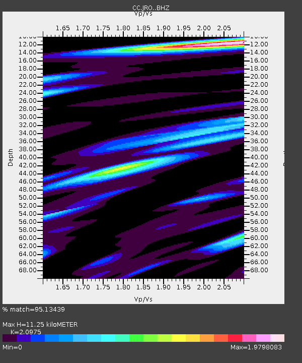
| Estimated Moho Depth: |
11.25 km |
| Estimated Crust Vp/Vs: |
2.10 |
| Assumed Crust Vp: |
6.566 km/s |
| Estimated Crust Vs: |
3.13 km/s |
| Estimated Crust Poisson's Ratio: |
0.35 |
|
| Radial Match: |
95.13439 % |
| Radial Bump: |
400 |
| Transverse Match: |
90.93028 % |
| Transverse Bump: |
400 |
| SOD ConfigId: |
7422571 |
| Insert Time: |
2019-04-19 16:10:04.715 +0000 |
| GWidth: |
2.5 |
| Max Bumps: |
400 |
| Tol: |
0.001 |
|

Signal To Noise
| Channel | StoN | STA | LTA |
| CC:JRO: :BHZ:20150707T05:19:58.364978Z | 31.069592 | 3.2451956E-6 | 1.0444925E-7 |
| CC:JRO: :BHN:20150707T05:19:58.364978Z | 17.895517 | 1.7127767E-6 | 9.570982E-8 |
| CC:JRO: :BHE:20150707T05:19:58.364978Z | 20.37301 | 1.820922E-6 | 8.937912E-8 |
| Arrivals |
| Ps | 2.0 SECOND |
| PpPs | 5.1 SECOND |
| PsPs/PpSs | 7.1 SECOND |


