You are here: Home > Network List > CB - China National Seismic Network Stations List
> Station CD2 Chengdou,Sichuan Province > Earthquake Result Viewer
CD2 Chengdou,Sichuan Province - Earthquake Result Viewer
| Earthquake location: |
Kuril Islands |
| Earthquake latitude/longitude: |
44.0/147.9 |
| Earthquake time(UTC): |
2015/07/07 (188) 05:10:27 GMT |
| Earthquake Depth: |
38 km |
| Earthquake Magnitude: |
6.3 MO |
| Earthquake Catalog/Contributor: |
NEIC PDE/NEIC ALERT |
|
| Network: |
CB China National Seismic Network |
| Station: |
CD2 Chengdou,Sichuan Province |
| Lat/Lon: |
30.91 N/103.76 E |
| Elevation: |
653 m |
|
| Distance: |
37.0 deg |
| Az: |
264.505 deg |
| Baz: |
56.719 deg |
| Ray Param: |
0.07629877 |
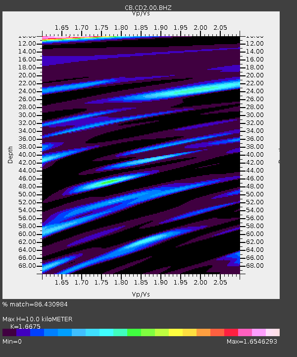
| Estimated Moho Depth: |
10.0 km |
| Estimated Crust Vp/Vs: |
1.67 |
| Assumed Crust Vp: |
6.159 km/s |
| Estimated Crust Vs: |
3.693 km/s |
| Estimated Crust Poisson's Ratio: |
0.22 |
|
| Radial Match: |
86.430984 % |
| Radial Bump: |
400 |
| Transverse Match: |
69.12219 % |
| Transverse Bump: |
400 |
| SOD ConfigId: |
7422571 |
| Insert Time: |
2019-04-19 16:10:11.385 +0000 |
| GWidth: |
2.5 |
| Max Bumps: |
400 |
| Tol: |
0.001 |
|

Signal To Noise
| Channel | StoN | STA | LTA |
| CB:CD2:00:BHZ:20150707T05:17:02.46001Z | 18.33104 | 6.368829E-6 | 3.4743414E-7 |
| CB:CD2:00:BHN:20150707T05:17:02.46001Z | 4.6418266 | 1.411305E-6 | 3.0404087E-7 |
| CB:CD2:00:BHE:20150707T05:17:02.46001Z | 4.3155313 | 2.0880746E-6 | 4.8385107E-7 |
| Arrivals |
| Ps | 1.2 SECOND |
| PpPs | 4.0 SECOND |
| PsPs/PpSs | 5.2 SECOND |


