You are here: Home > Network List > CI - Caltech Regional Seismic Network Stations List
> Station SMM Simmler, CA, USA > Earthquake Result Viewer
SMM Simmler, CA, USA - Earthquake Result Viewer
| Earthquake location: |
Kuril Islands |
| Earthquake latitude/longitude: |
44.0/147.9 |
| Earthquake time(UTC): |
2015/07/07 (188) 05:10:27 GMT |
| Earthquake Depth: |
38 km |
| Earthquake Magnitude: |
6.3 MO |
| Earthquake Catalog/Contributor: |
NEIC PDE/NEIC ALERT |
|
| Network: |
CI Caltech Regional Seismic Network |
| Station: |
SMM Simmler, CA, USA |
| Lat/Lon: |
35.31 N/120.00 W |
| Elevation: |
599 m |
|
| Distance: |
67.9 deg |
| Az: |
61.931 deg |
| Baz: |
308.847 deg |
| Ray Param: |
0.056620006 |
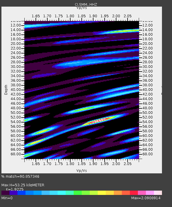
| Estimated Moho Depth: |
53.25 km |
| Estimated Crust Vp/Vs: |
1.92 |
| Assumed Crust Vp: |
6.1 km/s |
| Estimated Crust Vs: |
3.173 km/s |
| Estimated Crust Poisson's Ratio: |
0.31 |
|
| Radial Match: |
90.857346 % |
| Radial Bump: |
400 |
| Transverse Match: |
88.00206 % |
| Transverse Bump: |
400 |
| SOD ConfigId: |
7422571 |
| Insert Time: |
2019-04-19 16:11:00.768 +0000 |
| GWidth: |
2.5 |
| Max Bumps: |
400 |
| Tol: |
0.001 |
|

Signal To Noise
| Channel | StoN | STA | LTA |
| CI:SMM: :HHZ:20150707T05:20:49.747974Z | 22.536213 | 2.6872538E-6 | 1.1924159E-7 |
| CI:SMM: :HHN:20150707T05:20:49.747974Z | 8.270603 | 1.2687865E-6 | 1.5340918E-7 |
| CI:SMM: :HHE:20150707T05:20:49.747974Z | 4.1604652 | 9.3668893E-7 | 2.2514043E-7 |
| Arrivals |
| Ps | 8.3 SECOND |
| PpPs | 25 SECOND |
| PsPs/PpSs | 33 SECOND |


